IMAGES TAKEN NEAR TO
LN7 6BZ
Introduction
This page details the photographs taken nearby to LN7 6BZ by members of the Geograph project.
The Geograph project started in 2005 with the aim of publishing, organising and preserving representative images for every square kilometre of Great Britain, Ireland and the Isle of Man.

There are currently over 7.5m images from over14,400 individuals and you can help contribute to the project by visiting https://www.geograph.org.uk
Image Map
Images are licensed for reuse under creativecommons.org/licenses/by-sa/2.0
Notes
- Clicking on the map will re-center to the selected point.
- The higher the marker number, the further away the image location is from the centre of the postcode.
Image Listing (17 Images Found)
Images are licensed for reuse under creativecommons.org/licenses/by-sa/2.0
Image
Details
Distance
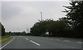
2
Leaving Nettleton
Heading south west on Holton Road (A46).
Image: © JThomas
Taken: 12 Apr 2014
0.05 miles
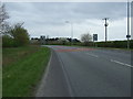
3
Moortown Road (B1205)
Heading west out of Nettleton.
Image: © JThomas
Taken: 12 Apr 2014
0.15 miles
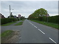
4
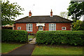
Memorial Cottage on Moortown Road, Nettleton
Dated 1922.
Image: © Ian S
Taken: 13 May 2018
0.18 miles
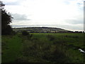
5
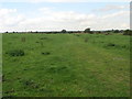
Path to Caistor
This path appears to have some temporary paving as it passes through this field.
Image: © Michael Patterson
Taken: 26 Sep 2006
0.18 miles
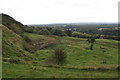
8
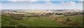
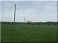
Nettleton panorama
Looking north from the permissive path near the top of Nettleton Hill.
Image: © David P Howard
Taken: 11 Mar 2016
0.19 miles
9
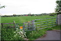
Nettleton Top
This image shows Nettleton Top, and was taken beside Nettleton Beck on the path between a small wooden bridge and a stile.
Image: © brian stopper
Taken: 16 Oct 2007
0.20 miles