IMAGES TAKEN NEAR TO
Clive Avenue, LINCOLN, LN6 7UH
Introduction
This page details the photographs taken nearby to Clive Avenue, LN6 7UH by members of the Geograph project.
The Geograph project started in 2005 with the aim of publishing, organising and preserving representative images for every square kilometre of Great Britain, Ireland and the Isle of Man.

There are currently over 7.5m images from over14,400 individuals and you can help contribute to the project by visiting https://www.geograph.org.uk
Image Map
Images are licensed for reuse under creativecommons.org/licenses/by-sa/2.0
Notes
- Clicking on the map will re-center to the selected point.
- The higher the marker number, the further away the image location is from the centre of the postcode.
Image Listing (8 Images Found)
Images are licensed for reuse under creativecommons.org/licenses/by-sa/2.0
Image
Details
Distance
1
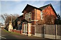
Boultham Park Lodge
Presumably contemporary with Boultham Hall, built in 1874. The Hall was the home of the Ellison family, used as a convalescent home during the first world war and sold to the City Council in 1929. Unable to find a suitable use for the building, it was eventually demolished in 1959 and the grounds used as a public park. This lodge and solitary gatepier stand at the entrance to Hall Drive from Boultham Park Road.
Image: © Richard Croft
Taken: 1 Jan 2007
0.14 miles
2
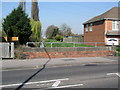
Lincoln, Boultham Park Road, bridge
The bridge carries a cut bench mark on the left-hand end of the parapet. See http://www.geograph.org.uk/photo/2903560 for a close-up and http://www.bench-marks.org.uk/bm42594 for details.
Image: © Brian Westlake
Taken: 28 Mar 2012
0.19 miles
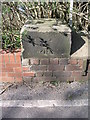
3
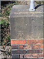
Cut Mark: Lincoln, Boultham Park Road, bridge
See http://www.geograph.org.uk/photo/2903545 for a wider view and http://www.bench-marks.org.uk/bm42594 for details.
Image: © Brian Westlake
Taken: 28 Mar 2012
0.19 miles
4
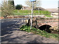
Lincoln, Hall Drive, bridge
The bridge carries a cut bench mark on the left-hand end of the far parapet. See http://www.geograph.org.uk/photo/2903607 for a close-up and http://www.bench-marks.org.uk/bm42597 for details.
Image: © Brian Westlake
Taken: 28 Mar 2012
0.20 miles
5
Cut Mark: Lincoln, Hall Drive, bridge
See http://www.geograph.org.uk/photo/2903602 for a wider view and http://www.bench-marks.org.uk/bm42597 for details.
Image: © Brian Westlake
Taken: 28 Mar 2012
0.20 miles
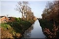
6
Footbridge over Catchwater Drain
The concrete bridge is dated 1964.
Image: © Julian P Guffogg
Taken: 4 May 2017
0.20 miles
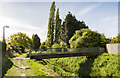
7
Catchwater Drain
Catchwater Drain and Altham Terrace looking east from Hall Drive
Image: © Richard Croft
Taken: 1 Jan 2007
0.21 miles
8
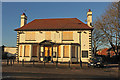
The Victory
Former pub on Boultham Park Road, The Victory was built in 1919 to commemorate the end of the First World War in 1918, closed in 2014.
Image: © Richard Croft
Taken: 14 Jan 2015
0.24 miles