IMAGES TAKEN NEAR TO
Hawthorn Corner, LINCOLN, LN5 9FF
Introduction
This page details the photographs taken nearby to Hawthorn Corner, LN5 9FF by members of the Geograph project.
The Geograph project started in 2005 with the aim of publishing, organising and preserving representative images for every square kilometre of Great Britain, Ireland and the Isle of Man.

There are currently over 7.5m images from over14,400 individuals and you can help contribute to the project by visiting https://www.geograph.org.uk
Image Map
Images are licensed for reuse under creativecommons.org/licenses/by-sa/2.0
Notes
- Clicking on the map will re-center to the selected point.
- The higher the marker number, the further away the image location is from the centre of the postcode.
Image Listing (44 Images Found)
Images are licensed for reuse under creativecommons.org/licenses/by-sa/2.0
Image
Details
Distance
1
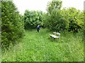
Sibsey Wood
This 2 hectare plot was given by the Neville Estate to the Woodland Trust in 1999. The wood was planted in a day on February 20th 2000 with the help of local people as a lasting commemoration of the Millennium. The tree on the left is a Wellingtonia, one of a small circle of these trees which in time will become the tallest trees in the wood.
Image: © Oliver Dixon
Taken: 17 Jun 2012
0.08 miles
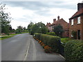
3

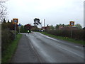
Chapel Lane, Auborn
The village of Auborn operates a one-way system. Chapel Lane to the south goes west and Royal Oak Lane to the north goes east.
Image: © Marathon
Taken: 12 Aug 2017
0.09 miles
4
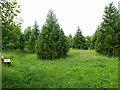
Sibsey Wood
The 2 hectare plot was given by the Neville Estate to the Woodland Trust in 1999. The wood was planted in a day on February 20th 2000 with the help of local people as a lasting commemoration of the Millennium. The circle of Wellingtonias towards the north-east corner of the wood will in time become the tallest trees in the wood.
Image: © Oliver Dixon
Taken: 17 Jun 2012
0.10 miles
6
Chapel Lane, Auborn
The village of Auborn operates a one-way system. Chapel Lane to the south goes west and Royal Oak Lane to the north goes east.
Image: © Marathon
Taken: 12 Aug 2017
0.10 miles
7
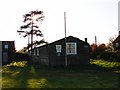
Aubourn and Haddington Village Hall
Still standing, but for how much longer?
Image: © Ian Paterson
Taken: 19 Apr 2009
0.12 miles
8
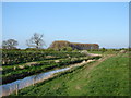
River Witham
View eastwards from a point near the road bridge.
Image: © Ian Paterson
Taken: 19 Apr 2009
0.15 miles
9
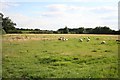
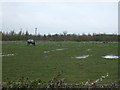
Aubourn sheep
Sheep grazing at Aubourn
Image: © Richard Croft
Taken: 23 Aug 2008
0.16 miles
10
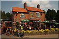
The Royal Oak
Refreshments at the Royal Oak in Aubourn
Image: © Richard Croft
Taken: 7 Jul 2013
0.16 miles