IMAGES TAKEN NEAR TO
Canwick Road, LINCOLN, LN5 8ET
Introduction
This page details the photographs taken nearby to Canwick Road, LN5 8ET by members of the Geograph project.
The Geograph project started in 2005 with the aim of publishing, organising and preserving representative images for every square kilometre of Great Britain, Ireland and the Isle of Man.

There are currently over 7.5m images from over14,400 individuals and you can help contribute to the project by visiting https://www.geograph.org.uk
Image Map
Images are licensed for reuse under creativecommons.org/licenses/by-sa/2.0
Notes
- Clicking on the map will re-center to the selected point.
- The higher the marker number, the further away the image location is from the centre of the postcode.
Image Listing (43 Images Found)
Images are licensed for reuse under creativecommons.org/licenses/by-sa/2.0
Image
Details
Distance
1
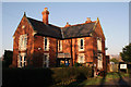
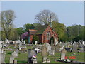
New Cemetery Lodge, Washingborough Road, Lincoln
The 11 acres of cemetery land was purchased in 1896 for £250 and the cemetery opened in 1897. Presumably the lodge was built in this period.
Image: © Jo and Steve Turner
Taken: 30 Dec 2019
0.00 miles
2
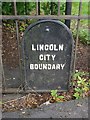
Old Boundary Marker by the B1190, Washingborough Road, Canwick
Municipal Boundary Marker by the B1190, in parish of Lincoln (Lincoln District), Washingborough Road. Unusually attached to a 'kissing gate' by iron fence next to Canwick Old Cemetery.
Inscription reads:-
LINCOLN
CITY
BOUNDARY
To be surveyed
Milestone Society National ID: LI_LINC01pb
Image: © Milestone Society
Taken: Unknown
0.08 miles
3
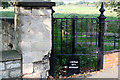
Lincoln City boundary
The 'Parliamentary Borough Boundary' running down the B1190 and then turning here between the Cow Paddle and Old Cemetery is shown on the OS maps up to 1950. It appears to have been defined along with the Canwick Enclosure award in 1787 and was in place until 1967 when it was revised to its current position along the B1190 Washingborough Road to encompass the sewage works. The Crematorium was built in 1968 but I don't know if this had any influence on the boundary change.
Image: © Jo and Steve Turner
Taken: 21 Sep 2008
0.08 miles
4
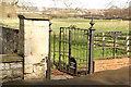
City Boundary
Lincoln City Boundary marker on Washingborough Road, on the kissing gate for the footpath to Cow Paddle
Image: © Richard Croft
Taken: 30 Mar 2016
0.08 miles
5
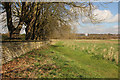
Cow Paddle
Ancient thoroughfare along the City boundary to Cow Paddle
Image: © Richard Croft
Taken: 30 Mar 2016
0.09 miles
6
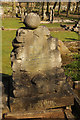
Canwick Road New Cemetery
Unusual football-themed headstone in Canwick Road New Cemetery to William Gibson who died September 15th 1911 aged 43
Image: © Richard Croft
Taken: 30 Mar 2016
0.09 miles
7

Canwick Road New Cemetery
Avenue in Canwick Road New Cemetery
Image: © Richard Croft
Taken: 30 Mar 2016
0.09 miles
8
Canwick, Old Cemetery, Canwick, nr Washingborough
Very large cemetery
Image: © Elaine
Taken: 25 Apr 2005
0.09 miles
9
Canwick Road New Cemetery
Early 20th century headstones in Canwick Road New Cemetery
Image: © Richard Croft
Taken: 30 Mar 2016
0.10 miles
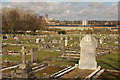
10
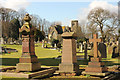
Canwick Road Old Cemetery
Late 19th and early 20th century headstones in Canwick Road Old Cemetery
Image: © Richard Croft
Taken: 30 Mar 2016
0.11 miles