IMAGES TAKEN NEAR TO
Archer Street, LINCOLN, LN5 7LQ
Introduction
This page details the photographs taken nearby to Archer Street, LN5 7LQ by members of the Geograph project.
The Geograph project started in 2005 with the aim of publishing, organising and preserving representative images for every square kilometre of Great Britain, Ireland and the Isle of Man.

There are currently over 7.5m images from over14,400 individuals and you can help contribute to the project by visiting https://www.geograph.org.uk
Image Map
Images are licensed for reuse under creativecommons.org/licenses/by-sa/2.0
Notes
- Clicking on the map will re-center to the selected point.
- The higher the marker number, the further away the image location is from the centre of the postcode.
Image Listing (265 Images Found)
Images are licensed for reuse under creativecommons.org/licenses/by-sa/2.0
Image
Details
Distance
1
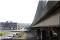
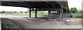
Canwick Road going over Great Northern Terrace
Image: © David Howard
Taken: 24 Jun 2019
0.04 miles
2
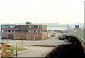
Witham House
Before development into the Pelham Centre. Note the stairway from the bridge to the roof car park now replaced by a spiral staircase. The slope to the roof car park (opp. side) is electrically heated to clear ice in winter. See Image to compare with 2011
Image: © Jo and Steve Turner
Taken: 20 Aug 1989
0.05 miles
3
Witham House
Now the Pelham Centre only the upper two floors are Witham House and are currently used by the Lincolnshire Road Safety Partnership (LRSP, formed June 2000). The roof has sprouted many aerials. Compare to a photo taken in 1989 Image
Image: © Jo and Steve Turner
Taken: 23 Oct 2011
0.05 miles
5
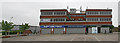
Witham House
Now the Pelham Centre only the upper two floors are Witham House and are currently used by the Lincolnshire Road Safety Partnership (LRSP, formed June 2000). The roof has sprouted many aerials.
Image: © Jo and Steve Turner
Taken: 20 May 2012
0.06 miles
6
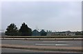
Pelham Street
Taken from Pelham bridge, the truncated Pelham street and the two businesses here are soon to be replaced with a new east-west relief road connecting Tentercroft Street to the Kesteven Street & Great Northern Terrace roundabout. Subject to planning, work will start in 2013.
Image: © Jo and Steve Turner
Taken: 20 May 2012
0.07 miles
7
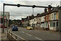
Canwick Road, Lincoln
Looking south along Canwick Road in Lincoln. Lights on the gantry above the road indicate which lanes are open to cars in both directions.
Image: © Graham Robson
Taken: 12 Jul 2023
0.07 miles
8
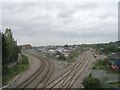
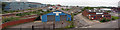
Pelham Bridge and the old coal yard
Network Rail would have High Street crossing closed (but don't want to pay for a foot bridge) however they still have plans to increase the amount of freight traffic through Lincoln. To help to mitigate some of the impact of that, this is the proposed route of a new east-west relief road connecting Tentercroft Street to the Kesteven Street & Great Northern Terrace roundabout. Subject to planning, work will start in 2013.
Update: Work on the £22m relief road eventually started in November 2014 and it opened in August 2016.
Image: © Jo and Steve Turner
Taken: 20 May 2012
0.08 miles
9
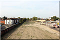
Old coal yard
Network Rail would have High Street crossing closed (but will not pay for a foot bridge) however they still have plans to increase the amount of freight traffic through Lincoln. To help to mitigate some of the impact of that, this is the proposed route of a new east-west relief road connecting Tentercroft Street to the Kesteven Street & Great Northern Terrace roundabout. Subject to planning, work will start in 2013.
Image: © Jo and Steve Turner
Taken: 23 Oct 2011
0.09 miles
10
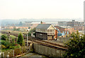
Pelham Street signal box
Pelham Street signal box was located by the Down Main line alongside Pelham bridge (at one time next to the Durham Ox crossing) and was a Great Northern Railway Type 1 design which opened in 1873 fitted with an 80 lever Rapier 1870 Patent frame, replacing an 1867-built signal box. On 20th July 1918 a replacement Tyer-manufactured 100 lever Great Northern Railway Duplex frame (frame number 4419) was installed. The signal box was closed on 19th July 2008 and was demolished on 18-19th August 2008, although officially it closed on 1st September 2008 when signalling passed to Lincoln Signalling Centre
Image: © Jo and Steve Turner
Taken: 20 Aug 1989
0.09 miles