IMAGES TAKEN NEAR TO
Lewis Street, LINCOLN, LN5 7LD
Introduction
This page details the photographs taken nearby to Lewis Street, LN5 7LD by members of the Geograph project.
The Geograph project started in 2005 with the aim of publishing, organising and preserving representative images for every square kilometre of Great Britain, Ireland and the Isle of Man.

There are currently over 7.5m images from over14,400 individuals and you can help contribute to the project by visiting https://www.geograph.org.uk
Image Map
Images are licensed for reuse under creativecommons.org/licenses/by-sa/2.0
Notes
- Clicking on the map will re-center to the selected point.
- The higher the marker number, the further away the image location is from the centre of the postcode.
Image Listing (434 Images Found)
Images are licensed for reuse under creativecommons.org/licenses/by-sa/2.0
Image
Details
Distance
1
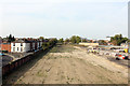
Old coal yard
Network Rail would have High Street crossing closed (but will not pay for a foot bridge) however they still have plans to increase the amount of freight traffic through Lincoln. To help to mitigate some of the impact of that, this is the proposed route of a new east-west relief road connecting Tentercroft Street to the Kesteven Street & Great Northern Terrace roundabout. Subject to planning, work will start in 2013.
Image: © Jo and Steve Turner
Taken: 23 Oct 2011
0.04 miles
2

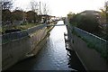
Waterway in Lincoln
The waterway leads to the railway station. The road is Sincil Bank, home of Lincoln City FC. The ground is about 80 mtrs behind the photo.
Image: © nick macneill
Taken: 18 Jun 2002
0.06 miles
3

Waste ground at junction in Tentercroft Street with County Council building in background
Ordnance Survey records indicate that in 1950 a benchmark was levelled at 6.385m above Newlyn Datum on #45 Tentercroft Street at this location. The mark is described on the Bench Mark Database at www.bench-marks.org.uk/bm40456
Image: © phil Richards
Taken: 11 Sep 2019
0.06 miles
4
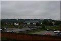
View south from the footbridge, Lincoln Central station
The road seen on the far side of the car parks marks the site of the former Lincoln St Marks station, which was on the former Midland Railway (Central being the former Great Northern Railway station).
Image: © Christopher Hilton
Taken: 25 Jun 2019
0.07 miles
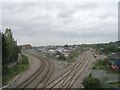
5
Sincil Drain
Looking south along Sincil Drain from Tentercroft Street
Image: © Richard Croft
Taken: 18 Nov 2006
0.07 miles

9

Sincil Drain
Looking north with the Cathedral on the horizon, Sincil Drain was reconstructed 1963-4 with concrete banks to reduce the risk of flooding in the lower city.
Image: © Richard Croft
Taken: 9 Jun 2006
0.08 miles
10

Benchmark on #35 Cross Street, Chelmsford Street face
Ordnance Survey cut mark benchmark described on the Bench Mark Database at www.bench-marks.org.uk/bm38045
Image: © phil Richards
Taken: 11 Sep 2019
0.08 miles