IMAGES TAKEN NEAR TO
Waterside South, LINCOLN, LN5 7JD
Introduction
This page details the photographs taken nearby to Waterside South, LN5 7JD by members of the Geograph project.
The Geograph project started in 2005 with the aim of publishing, organising and preserving representative images for every square kilometre of Great Britain, Ireland and the Isle of Man.

There are currently over 7.5m images from over14,400 individuals and you can help contribute to the project by visiting https://www.geograph.org.uk
Image Map
Images are licensed for reuse under creativecommons.org/licenses/by-sa/2.0
Notes
- Clicking on the map will re-center to the selected point.
- The higher the marker number, the further away the image location is from the centre of the postcode.
Image Listing (268 Images Found)
Images are licensed for reuse under creativecommons.org/licenses/by-sa/2.0
Image
Details
Distance
1
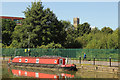
Narrowboat on the River Witham
A narrowboat moored at Stamp End on the River Witham
Image: © Richard Croft
Taken: 26 Aug 2013
0.03 miles
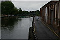
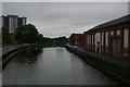
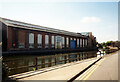
2
The River Witham, Lincoln
Narrow boat tied up alongside Waterside North.
Image: © Dave Hitchborne
Taken: 28 Aug 2013
0.03 miles
3
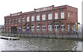
Clayton & Shuttleworth's Edwardian Office Block - Waterside South
The engineering company was formed in 1842 and closed in 1929.
Image: © Betty Longbottom
Taken: 4 Sep 2009
0.03 miles
4
Lincoln: River Witham Navigation, Stamp End Lock from footbridge
Image: © Christopher Hilton
Taken: 25 Jun 2019
0.03 miles
5
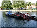
Weedcutting boat on the River Witham
For an image of weedcutting boats in action see Image
Image: © Oliver Dixon
Taken: 11 Oct 2012
0.03 miles
6
Lincoln: River Witham Navigation, Stamp End Lock from footbridge
Image: © Christopher Hilton
Taken: 25 Jun 2019
0.03 miles
7
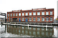
Clayton & Shuttleworth offices
Former offices of Clayton & Shuttleworth at Stamp End, seen across the River Witham
Image: © Richard Croft
Taken: 31 Dec 2011
0.03 miles
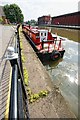
8
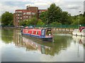
Narrowboat on the Witham Navigation
Narrowboat "Foster's Folly" on the Witham Navigation, just to the east of Lincoln city centre. The River Witham (Witham Navigation) is navigable for 36 miles from Lincoln, High Bridge (the Glory Hole), where it joins the Fossdyke Canal, to the mouth of the river at Hobhole Drain.
Image: © David Dixon
Taken: 5 Aug 2014
0.04 miles
9
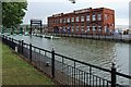
The former Clayton & Shuttleworth Stamp End Works, Lincoln
Clayton & Shuttleworth was a famous engineering company, located at the Stamp End Works. It was established in 1842 when Nathaniel Clayton formed a partnership with his brother-in-law, Joseph Shuttleworth.
Image: © Dave Hitchborne
Taken: 11 Jul 2008
0.04 miles
10
Ruston's Training School, Waterside North, Lincoln
Siemens Industrial Turbomachinery Ltd. Bays 28 and 29. In the early 1970s (when I was here) this was the Ruston Training Centre. West of the former basin, this was probably on land owned by Shuttleworth from 1841 and as such will have been one of the earlier buildings of the 1850s to 1880s. The walls, whilst largely original, have had changes in fenestration and on waterside South, doorways inserted. The east gable wall is metal clad and adjacent brickwork on the north façade looks relatively modern. What can be seen of the west gable is original.
Image: © Jo and Steve Turner
Taken: 24 Sep 1989
0.04 miles