IMAGES TAKEN NEAR TO
Heathcote Road, LINCOLN, LN4 4SB
Introduction
This page details the photographs taken nearby to Heathcote Road, LN4 4SB by members of the Geograph project.
The Geograph project started in 2005 with the aim of publishing, organising and preserving representative images for every square kilometre of Great Britain, Ireland and the Isle of Man.

There are currently over 7.5m images from over14,400 individuals and you can help contribute to the project by visiting https://www.geograph.org.uk
Image Map
Images are licensed for reuse under creativecommons.org/licenses/by-sa/2.0
Notes
- Clicking on the map will re-center to the selected point.
- The higher the marker number, the further away the image location is from the centre of the postcode.
Image Listing (8 Images Found)
Images are licensed for reuse under creativecommons.org/licenses/by-sa/2.0
Image
Details
Distance
1
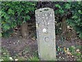
Old Boundary Marker on the south side of the A153
Highway Authority boundary marker on the south side of the A153 Tumby Road. Coningsby parish. Inscribed L / C / C (Lindsey County Council).
Milestone Society National ID: LI_CONING01pb
Image: © D Pitcher
Taken: Unknown
0.05 miles
2
Site of Coningsby station, 1983
View eastward from the A155, towards Firsby: ex-GN Woodhall Junction - Firsby (Bellwater Junction) line. The station and line were closed from 5/10/70: in 1983 nothing but the formation was left.
Image: © Ben Brooksbank
Taken: 25 Aug 1983
0.12 miles
3
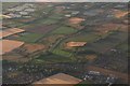
Cropmarks and earthworks on site NE of Coningsby: aerial 2018
Centred on grass field by Wharfe Lane.
Image: © Chris
Taken: 28 Jul 2018
0.17 miles
4
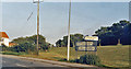
Pilgrim Square
Junction of the A153 and Pilgrim Square, Coningsby
Image: © Donnylad
Taken: 12 Jun 2007
0.19 miles
5
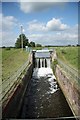
Coningsby Lock
Disused lock on the Horncastle Canal / River Bain
Image: © Richard Croft
Taken: 28 May 2009
0.24 miles
6
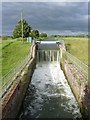
Coningsby Lock
The former lock chamber has been reused as a suitable means of controlling water flow in the canalised River Bain/Horncastle Canal. The side walls of the lock would have originally extended to at least the height of the water level beyond. Water flow seemed still quite high for the time of year following the June 2012 rains.
Image: © Alan Murray-Rust
Taken: 1 Jul 2012
0.25 miles
7
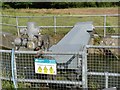
Coningsby Lock weir mechanism
Used for controlling water levels in the River Bain to prevent flooding.
Image: © Alan Murray-Rust
Taken: 1 Jul 2012
0.25 miles
8
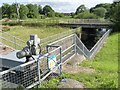
Coningsby Lock
The lock walls would have continued at about the height of the nearest coping. The recess for the lower gates of the lock can just be made out this side of the road bridge.
Image: © Alan Murray-Rust
Taken: 1 Jul 2012
0.25 miles