IMAGES TAKEN NEAR TO
Elizabeth Avenue, LINCOLN, LN4 4JJ
Introduction
This page details the photographs taken nearby to Elizabeth Avenue, LN4 4JJ by members of the Geograph project.
The Geograph project started in 2005 with the aim of publishing, organising and preserving representative images for every square kilometre of Great Britain, Ireland and the Isle of Man.

There are currently over 7.5m images from over14,400 individuals and you can help contribute to the project by visiting https://www.geograph.org.uk
Image Map
Images are licensed for reuse under creativecommons.org/licenses/by-sa/2.0
Notes
- Clicking on the map will re-center to the selected point.
- The higher the marker number, the further away the image location is from the centre of the postcode.
Image Listing (7 Images Found)
Images are licensed for reuse under creativecommons.org/licenses/by-sa/2.0
Image
Details
Distance
1
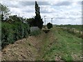
Drain off A153, near Tattershall Bridge
Image: © J.Hannan-Briggs
Taken: 20 Aug 2011
0.12 miles
2
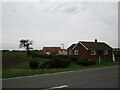
Vine Lea
A bungalow built on the site of an earlier dwelling. Many of the farms in the Fens were very small (both as buildings and holdings) and unstable ground led to their early demise, or in this case, replacement.
Image: © Jonathan Thacker
Taken: 20 Oct 2020
0.14 miles
3
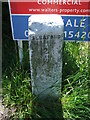
Old Milestone
Old mile milestone at Tattershall Bridge, Lincolnshire for overall view see http://www.geograph.org.uk/photo/3511453
Image: © Keith Evans
Taken: 6 Jun 2013
0.17 miles
4
Old Milestone
Old mile milestone at Tattershall Bridge, Lincolnshire for close up view see http://www.geograph.org.uk/photo/3511450
Image: © Keith Evans
Taken: 6 Jun 2013
0.17 miles
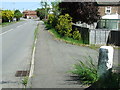
5
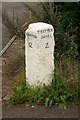
Tattershall Bridge milestone
Milestone on Old Sleaford Road near Tattershall Bridge
Image: © Richard Croft
Taken: 17 Sep 2008
0.19 miles
6
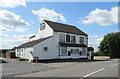
The Royal Oak, Tattershall Bridge
On the old A153, now by-passed.
Image: © JThomas
Taken: 17 Jul 2020
0.24 miles
7
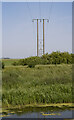
Electricity poles and cables
Here crossing Billinghay Skirth.
Image: © Julian P Guffogg
Taken: 13 Jun 2023
0.24 miles