IMAGES TAKEN NEAR TO
Clay Bank, LINCOLN, LN4 4AJ
Introduction
This page details the photographs taken nearby to Clay Bank, LN4 4AJ by members of the Geograph project.
The Geograph project started in 2005 with the aim of publishing, organising and preserving representative images for every square kilometre of Great Britain, Ireland and the Isle of Man.

There are currently over 7.5m images from over14,400 individuals and you can help contribute to the project by visiting https://www.geograph.org.uk
Image Map
Images are licensed for reuse under creativecommons.org/licenses/by-sa/2.0
Notes
- Clicking on the map will re-center to the selected point.
- The higher the marker number, the further away the image location is from the centre of the postcode.
Image Listing (14 Images Found)
Images are licensed for reuse under creativecommons.org/licenses/by-sa/2.0
Image
Details
Distance
2
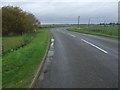
A bend in Clay Bank (B1395)
Heading north towards South Kyme.
Image: © JThomas
Taken: 18 Oct 2014
0.05 miles
3
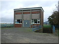
Heckington Fen Pumping Station south of South Kyme, November 2019 floods
Five Willow Wath Bridge.
Image: © Chris
Taken: 14 Nov 2019
0.08 miles
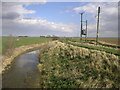
4
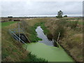
Head Dike
Looking west from Five Willow Wath Bridge.
Image: © JThomas
Taken: 18 Oct 2014
0.08 miles
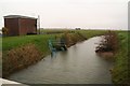
5
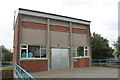
Heckington Fen Pumping Station
On Head Dyke.
Image: © J.Hannan-Briggs
Taken: 30 Sep 2012
0.10 miles
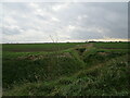
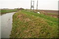
7
Head Dike
I assume this dike is in charge of a number of the others in the area. Either that or it is the highest above sea level.
Image: © Michael Patterson
Taken: 10 Apr 2006
0.14 miles
9
Five Willow Wath Bridge, South Kyme: November 2019 floods
Image: © Chris
Taken: 14 Nov 2019
0.16 miles
10
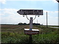
Farm Signpost
Featuring Five Willow Wath Farm and the B1395 in the distance.
Image: © Ian Paterson
Taken: 7 Sep 2007
0.16 miles