IMAGES TAKEN NEAR TO
Kingfisher Court, LINCOLN, LN4 3LL
Introduction
This page details the photographs taken nearby to Kingfisher Court, LN4 3LL by members of the Geograph project.
The Geograph project started in 2005 with the aim of publishing, organising and preserving representative images for every square kilometre of Great Britain, Ireland and the Isle of Man.

There are currently over 7.5m images from over14,400 individuals and you can help contribute to the project by visiting https://www.geograph.org.uk
Image Map (Loading...)


Getting Data...Please wait
Leaflet Map data © OpenStreetMap
Images are licensed for reuse under creativecommons.org/licenses/by-sa/2.0
Notes
- Clicking on the map will re-center to the selected point.
- The higher the marker number, the further away the image location is from the centre of the postcode.
Image Listing (12 Images Found)
Images are licensed for reuse under creativecommons.org/licenses/by-sa/2.0
Image
Details
Distance
2
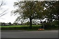
No-one starves here: free giant pumpkins by the roadside in former R.A.F. Digby
Image: © Chris
Taken: 29 Oct 2017
0.15 miles
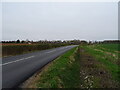
4
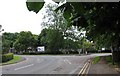
Double yellow lines on approach to former R.A.F. Digby
Now the Joint Service Signal Unit (D) - the RAF ensign was lowered for the last time on 1st June 2011.
See https://www.raf.mod.uk/rafdigby/aboutus/history.cfm
Image: © Chris
Taken: 29 Oct 2017
0.18 miles
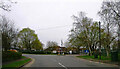
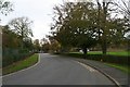
9
Entrance to RAF Digby
RAF Digby is the oldest station in the RAF. It is also the home of the RAF Aerial Erector School.
Image: © Andrew Tatlow
Taken: 23 Jun 2007
0.20 miles
10
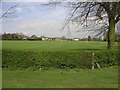
Sports Ground
This sports ground is in the village with no name north of Ashby de la Launde.
Image: © Michael Patterson
Taken: 25 Apr 2006
0.21 miles