IMAGES TAKEN NEAR TO
Lagonda Close, LINCOLN, LN4 2QH
Introduction
This page details the photographs taken nearby to Lagonda Close, LN4 2QH by members of the Geograph project.
The Geograph project started in 2005 with the aim of publishing, organising and preserving representative images for every square kilometre of Great Britain, Ireland and the Isle of Man.

There are currently over 7.5m images from over14,400 individuals and you can help contribute to the project by visiting https://www.geograph.org.uk
Image Map (Loading...)


Getting Data...Please wait
Leaflet Map data © OpenStreetMap
Images are licensed for reuse under creativecommons.org/licenses/by-sa/2.0
Notes
- Clicking on the map will re-center to the selected point.
- The higher the marker number, the further away the image location is from the centre of the postcode.
Image Listing (10 Images Found)
Images are licensed for reuse under creativecommons.org/licenses/by-sa/2.0
Image
Details
Distance
1
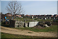
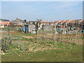
Waddington allotments
Allotment gardens on a sunny spring morning
Image: © Richard Croft
Taken: 10 Apr 2010
0.12 miles
2
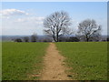
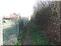
Footpath: Bracebridge Heath
An unofficial footpath between Vauxhall Road, Bracebridge Heath and the Viking Way across the top of the ridge.
Image: © Matthew Smith
Taken: 13 Mar 2007
0.15 miles
3
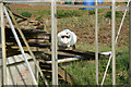
Mouse-hunting
A predatory cat stalks likely prey on the allotments at Waddington
Image: © Richard Croft
Taken: 10 Apr 2010
0.15 miles
7
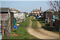
Waddington allotments
Allotment gardens at Waddington
Image: © Richard Croft
Taken: 10 Apr 2010
0.17 miles
8

Preparation works
Part of the construction of a major water main linking the north and south of Lincolnshire.
Image: © Jonathan Thacker
Taken: 21 Jun 2023
0.23 miles
9
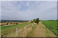
The Viking Way north on the 'Lincoln Cliff'
With views to the southern suburbs of Lincoln along the Witham Valley
Image: © Tim Heaton
Taken: 23 Aug 2013
0.23 miles
10
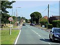
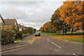
Bracebridge Heath, Grantham Road
The A607 briefly follows the route of the Roman Ermine Street at Bracebridge Heath.
Image: © David Dixon
Taken: 5 Aug 2014
0.23 miles