IMAGES TAKEN NEAR TO
Daniel Crescent, LINCOLN, LN4 1QT
Introduction
This page details the photographs taken nearby to Daniel Crescent, LN4 1QT by members of the Geograph project.
The Geograph project started in 2005 with the aim of publishing, organising and preserving representative images for every square kilometre of Great Britain, Ireland and the Isle of Man.

There are currently over 7.5m images from over14,400 individuals and you can help contribute to the project by visiting https://www.geograph.org.uk
Image Map
Images are licensed for reuse under creativecommons.org/licenses/by-sa/2.0
Notes
- Clicking on the map will re-center to the selected point.
- The higher the marker number, the further away the image location is from the centre of the postcode.
Image Listing (7 Images Found)
Images are licensed for reuse under creativecommons.org/licenses/by-sa/2.0
Image
Details
Distance
1
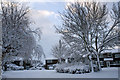
Snow in Oxford Close Washingborough
Image: © Jo and Steve Turner
Taken: 1 Dec 2010
0.13 miles
2
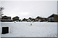
Snow in Yale Close, Washingborough
Image: © Jo and Steve Turner
Taken: 2 Dec 2010
0.20 miles
3
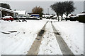
Snow in Marlborough Avenue, Washingborough
Image: © Jo and Steve Turner
Taken: 2 Dec 2010
0.21 miles
4
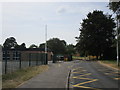
Entrance to Heighington Millfield Primary Academy
Image: © Jonathan Thacker
Taken: 25 Jul 2018
0.21 miles
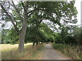
5
Claytops, Pits Wood, off Washingborough Road, Washingborough
The house carries a datestone for 1843 and indeed a building of similar footprint is shown on the 1887 OS map but probably a newer build incorporating parts of an earlier house.
Image: © Jo and Steve Turner
Taken: 10 Apr 2020
0.23 miles
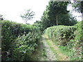
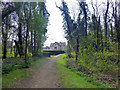
7
Track off Park Lane, Heighington
A restricted byway.
Image: © Jonathan Thacker
Taken: 25 Jul 2018
0.25 miles