IMAGES TAKEN NEAR TO
Chapel Lane, LINCOLN, LN4 1LA
Introduction
This page details the photographs taken nearby to Chapel Lane, LN4 1LA by members of the Geograph project.
The Geograph project started in 2005 with the aim of publishing, organising and preserving representative images for every square kilometre of Great Britain, Ireland and the Isle of Man.

There are currently over 7.5m images from over14,400 individuals and you can help contribute to the project by visiting https://www.geograph.org.uk
Image Map
Images are licensed for reuse under creativecommons.org/licenses/by-sa/2.0
Notes
- Clicking on the map will re-center to the selected point.
- The higher the marker number, the further away the image location is from the centre of the postcode.
Image Listing (64 Images Found)
Images are licensed for reuse under creativecommons.org/licenses/by-sa/2.0
Image
Details
Distance
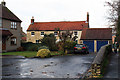
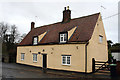
1
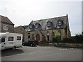
Former chapel, Branston
Now a house.
Image: © Jonathan Thacker
Taken: 25 Jul 2018
0.01 miles
2
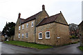
Summerdale, 1 Hall Lane, Branston
Mid 18th century Grade II Listed farmhouse. Summerdale was Springfield Farm, occupied in the 19th century by Henry Grimes II who appears to have moved out in the late 1880s to make way for his cousin William Grimes who had fallen on hard times. The 1891 census suggests he is here with farm foreman, William Pacey and family, and three lodging waggoners. It seems William Grimes was, in the early part of the 20th century, a local part time tax collector. The property is now a substantial refurbished 5 bedroom, 3 reception room home.
Image: © Jo and Steve Turner
Taken: 28 Nov 2019
0.04 miles
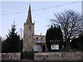
3
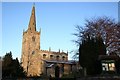
All Saints' church, Branston, Lincs.
Most of the church was destroyed by fire and rebuilt in 1963, but the Saxon tower with Perpendicular spire survive.
Image: © Richard Croft
Taken: Unknown
0.04 miles
4
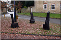
Carved seats, Village Green, Hall Lane, Branston
A project by the local history group the 2006-7 carvings reflect past, present and potential future uses of the produce grown in neighbouring fields, with wheat in the past, potatoes in the present and sunflowers in the future. Carving sessions were led by Newark artist Denise Marshall. This is reputedly the former location of the stocks.
Image: © Jo and Steve Turner
Taken: 28 Nov 2019
0.05 miles
5
Melville Close, Branston
Grade II Listed 18th century house. Listed as Co-op House a former farm house it is apparently now 4 Melville Close. The north-eastern two bays appear to be a later addition when compared to the profile and position of the building on late 19th and early 20th century maps. Indeed visually the two right hand bays that are rendered appear to have narrower first floor windows and it is possible it was two dwellings at some stage.
Image: © Jo and Steve Turner
Taken: 28 Nov 2019
0.07 miles
7
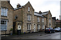
27-33 Silver Street, Branston
Early 19th century Grade II Listed row of cottages. Labelled on the OS map as Westward Cottages, I seem to remember the adjacent shop (35) was known as Westward's Shop in the 1950s/60s. Pevsner comments that they are 'in a Lovely style' in reference to Thomas Lovelee (1808-1877) a Corn Miller, Stonemason, and Lime Burner who built Stonefield House (14 Sleaford Road). Silver Street was formerly known as Bleak Street.
Image: © Jo and Steve Turner
Taken: 28 Nov 2019
0.08 miles
8
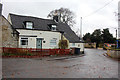
The Forge, 19 Church Road, Branston
Former blacksmiths. In the late 1950s and/or early 1960s if you knocked on the door and asked, the occupant, (I forget his name) would take you a few yards up the road to a shed and cut your hair for a small charge. An application to extend the property was apparently rejected in 2007.
Image: © Jo and Steve Turner
Taken: 28 Nov 2019
0.08 miles
9
The Bertie Arms, 10 Hall Lane, Branston
Grade II Listed former early 18th century inn. The former thatched Bertie Arms, converted by William Cucksey, was a home and dairy from 1912 until 1940. The pub was named after Lord Vere Bertie who built the Branston Hall that was destroyed by fire in 1904. The plaque reads 'IN THIS HOUSE FORMERLY AN INN KNOWN AS "THE BERTIE ARMS" WAS HELD ON THE 26TH MAY 1765 THE INAUGURAL MEETING TO INSTITUTE THE ENCLOSURE OF THE PARISH LANDS OF BRANSTON'. (In the years between 1760 and 1820 there was wholesale enclosure in which, in village after village, common rights were lost, described by E P Thompson as 'a plain enough case of class robbery'.) Felicia Richardson, one of the current (2020) owners has told me that they purchased it in 1986 and have subsequently renovated the interior which has mud and stud walls, two Inglenook fireplaces and very old oak beams. Felicia also informs me it was very briefly known as Berties Inn named by people who owned it for a few months prior to them.
Image: © Jo and Steve Turner
Taken: 28 Nov 2019
0.08 miles
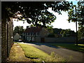
10
All Saints Church. Branston
History of the church here: http://homepage.ntlworld.com/peter.fairweather/docs/Branston_all_saints.htm
Image: © PAUL FARMER
Taken: 27 Nov 2011
0.10 miles