IMAGES TAKEN NEAR TO
Pitts Road, LINCOLN, LN4 1BH
Introduction
This page details the photographs taken nearby to Pitts Road, LN4 1BH by members of the Geograph project.
The Geograph project started in 2005 with the aim of publishing, organising and preserving representative images for every square kilometre of Great Britain, Ireland and the Isle of Man.

There are currently over 7.5m images from over14,400 individuals and you can help contribute to the project by visiting https://www.geograph.org.uk
Image Map
Images are licensed for reuse under creativecommons.org/licenses/by-sa/2.0
Notes
- Clicking on the map will re-center to the selected point.
- The higher the marker number, the further away the image location is from the centre of the postcode.
Image Listing (55 Images Found)
Images are licensed for reuse under creativecommons.org/licenses/by-sa/2.0
Image
Details
Distance
1
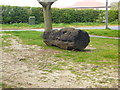
Carved Seat
Rear of community carved bench officially 'opened' 2nd May 2009.
Image: © Jo and Steve Turner
Taken: 10 Apr 2020
0.05 miles
2
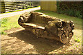
Park Lane bench
Carved bench on the corner of Pitts Road and Park Lane in Washingborough
Image: © Richard Croft
Taken: 6 May 2012
0.05 miles
3
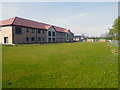
Brighton Place, Marion Close, Washingborough
Lace Housing's 26 two bedroom apartments for rent to the over 55s were completed in July and formally opened in September 2019. The building was named in memory of long-serving Lincolnshire councillor Marion Brighton OBE. There is a fully furnished communal lounge and kitchen, plus communal seating areas throughout. They were built by Lindum’s Construction division and created in conjunction with North Kesteven and Washingborough Parish councils. The £4.4m development was made possible thanks to a £1.6m grant from the Government’s Homes England as part its Shared Ownership and Affordable Homes programme. The development also includes 8 two bedroom bungalows for shared ownership.
Image: © Jo and Steve Turner
Taken: 12 Apr 2020
0.06 miles
4
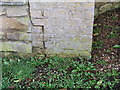
Washingborough, cut bench mark at entrance to Manor House
Cut bench mark on the left-hand gatepost in Pitts Road. See http://www.bench-marks.org.uk/bm32600 for details.
Image: © Brian Westlake
Taken: 23 Feb 2011
0.07 miles
5

The Precinct, Park Lane, Washingborough
I assume the precinct was built during development of the housing estate in the late 1960s or early 1970s. Completed in October 2015, the Lincolnshire Co-op invested about £750,000 in a complete refurbishment of its shops and the precinct area.
Image: © Jo and Steve Turner
Taken: 6 May 2012
0.14 miles
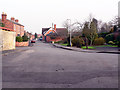
6

Pitts Road heading north
Into Washingborough.
Image: © JThomas
Taken: 20 Jul 2013
0.16 miles
7
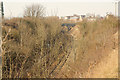
Washingborough cutting
Railway cutting from Pitts Road
Image: © Richard Croft
Taken: 2 Mar 2012
0.16 miles
8
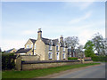
Manor Farmhouse, Church Hill, Washingborough
Grade II Listed mid 18th century farmhouse with early 19th century remodelling.
Image: © Jo and Steve Turner
Taken: 12 Apr 2020
0.16 miles
10
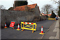
High Street
Just in case it falls down, this is the building opposite 15 High Street Washingborough. The road has been closed from 23/12/2011 and is not expected to re-open until the end of February 2012.
Image: © Jo and Steve Turner
Taken: 4 Feb 2012
0.17 miles