IMAGES TAKEN NEAR TO
Ferry Lane, LINCOLN, LN4 1AA
Introduction
This page details the photographs taken nearby to Ferry Lane, LN4 1AA by members of the Geograph project.
The Geograph project started in 2005 with the aim of publishing, organising and preserving representative images for every square kilometre of Great Britain, Ireland and the Isle of Man.

There are currently over 7.5m images from over14,400 individuals and you can help contribute to the project by visiting https://www.geograph.org.uk
Image Map
Images are licensed for reuse under creativecommons.org/licenses/by-sa/2.0
Notes
- Clicking on the map will re-center to the selected point.
- The higher the marker number, the further away the image location is from the centre of the postcode.
Image Listing (41 Images Found)
Images are licensed for reuse under creativecommons.org/licenses/by-sa/2.0
Image
Details
Distance
1
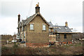
Washingborough Station
Continuing restoration of Washingborough Station
Image: © Richard Croft
Taken: 7 Jan 2012
0.00 miles
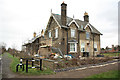
3

Washingborough Station
Continued restoration of the former Washingborough Station http://www.geograph.org.uk/photo/934251 http://www.geograph.org.uk/photo/2366826 on NCN route 1 / Water Rail Way
Image: © Richard Croft
Taken: 25 Oct 2016
0.01 miles
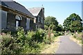
4
Washingborough Station
Restoration and improvements to Washingborough Station continue http://www.geograph.org.uk/photo/2366826
Image: © Richard Croft
Taken: 7 Jan 2012
0.01 miles
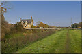
5
Washingborough Station
Opened in 1848, closed in the early 1970s, the station house is empty but currently being restored and the Water Rail Way cycle trail runs on the former track bed.
Image: © Richard Croft
Taken: 5 Aug 2007
0.01 miles
6
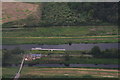
Former ferry crossing and station house on the River Witham at Washingborough: aerial 2015
L. and N.E.R. Line ran along the Witham bank between the river and South Delph - see Historic Map on Submit page of this site and Image
Image: © Chris
Taken: 7 Sep 2015
0.01 miles
7
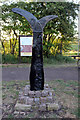
Sustrans Cycle Route 1 signpost by the Station House Washingborough
Cycle route one connects Dover to the Shetlands via London, the east coast of the UK, Edinburgh, John o'Groats and the Orkneys; it doubles as the North Sea Cycle Route. The National Route numbering system is similar to the original A-road numbering system introduced in the 1920's, with primary routes radiating clockwise from London, and their branches adding digits to the primary number.
Image: © Jo and Steve Turner
Taken: 24 May 2011
0.01 miles
8
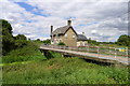
Ferry Lane crossing South Delph
The bridge connects the Visitor Moorings on the River Witham to the village of Washingborough
Image: © Tim Heaton
Taken: 27 Jul 2014
0.02 miles
9
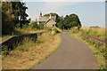
Water Rail Way
NCN route 1 / Water Rail Way through the site of Washingborough Station with platforms either side of the track
Image: © Richard Croft
Taken: 16 Jul 2015
0.02 miles
10
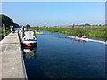
River Witham on Boston Rowing Marathon Day
Image: © Clive Nicholson
Taken: 20 Sep 2015
0.02 miles