IMAGES TAKEN NEAR TO
Cannon Street, LINCOLN, LN2 5EF
Introduction
This page details the photographs taken nearby to Cannon Street, LN2 5EF by members of the Geograph project.
The Geograph project started in 2005 with the aim of publishing, organising and preserving representative images for every square kilometre of Great Britain, Ireland and the Isle of Man.

There are currently over 7.5m images from over14,400 individuals and you can help contribute to the project by visiting https://www.geograph.org.uk
Image Map
Images are licensed for reuse under creativecommons.org/licenses/by-sa/2.0
Notes
- Clicking on the map will re-center to the selected point.
- The higher the marker number, the further away the image location is from the centre of the postcode.
Image Listing (255 Images Found)
Images are licensed for reuse under creativecommons.org/licenses/by-sa/2.0
Image
Details
Distance
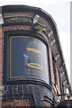
2
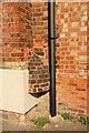
Urine deflector
A rare surviving urine deflector on the Winn Street elevation of The Birdcage https://www.geograph.org.uk/photo/7443213
Intended to deter men from urinating in a corner as the stream of urine would be deflected back on to their feet. A marvellous piece of social history.
Image: © Richard Croft
Taken: 27 Mar 2023
0.03 miles
3
Baggholme Rd, Lincoln
The Crown Inn - A visit to this pub will probably see you served by Britain's oldest barmaid who has turned 90, but still has 'no plans to retire', despite serving over THREE MILLION drinks during her 64-year career. Great-grandmother Joyce Leyshon has tallied up a remarkable 64 years of unbroken service in pubs and clubs and has no intention of calling time on her career. She has a 77-year-old toyboy and still enjoys a whisky and lemonade.
Image: © Dave Hitchborne
Taken: 28 Aug 2013
0.04 miles
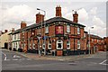
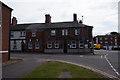
4
The Birdcage
Formerly The Crown Inn, built 1867 on the corner of Baggholme Road and Winn Street.
Image: © Richard Croft
Taken: 27 Mar 2023
0.04 miles
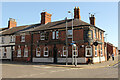
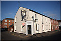
5
The Birdcage Public House
On Baggholme Road, Lincoln.
Image: © Ian S
Taken: 30 May 2019
0.04 miles
6
The Birdcage Public House
On Baggholme Road, Lincoln.
Image: © Ian S
Taken: 30 May 2019
0.04 miles
7
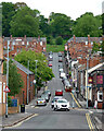
Baggholme Road, Lincoln
Part of a grid of Victorian streets built for factory workers in what was then an area full of factories. The continuation up the hill is Cheviot Street.
The pub on the corner, Crown Inn (Image]), is now the Birdcage.
Image: © Stephen Richards
Taken: 15 Jun 2015
0.04 miles
8
Steam Hammer flats
Former Steam Hammer Inn http://www.geograph.org.uk/photo/1059611 now converted to flats
Image: © Richard Croft
Taken: 15 Nov 2011
0.04 miles
9
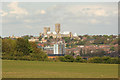
View to Lincoln
Long view from Canwick towards Lincoln with Shuttleworth House http://www.geograph.org.uk/photo/2784681 in the mid-ground and St.Mary's Cathedral http://www.geograph.org.uk/photo/2242797 dominating the skyline
Image: © Richard Croft
Taken: 6 May 2012
0.05 miles
10

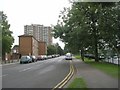
View from Heighington Road
Serried ranks of Victorian terraced houses south-east of Lincoln city centre.
Image: © Stephen Richards
Taken: 16 Jun 2015
0.06 miles