IMAGES TAKEN NEAR TO
Camshaws Road, LINCOLN, LN2 4ZH
Introduction
This page details the photographs taken nearby to Camshaws Road, LN2 4ZH by members of the Geograph project.
The Geograph project started in 2005 with the aim of publishing, organising and preserving representative images for every square kilometre of Great Britain, Ireland and the Isle of Man.

There are currently over 7.5m images from over14,400 individuals and you can help contribute to the project by visiting https://www.geograph.org.uk
Image Map (Loading...)


Getting Data...Please wait
Leaflet Map data © OpenStreetMap
Images are licensed for reuse under creativecommons.org/licenses/by-sa/2.0
Notes
- Clicking on the map will re-center to the selected point.
- The higher the marker number, the further away the image location is from the centre of the postcode.
Image Listing (14 Images Found)
Images are licensed for reuse under creativecommons.org/licenses/by-sa/2.0
Image
Details
Distance
1
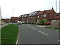
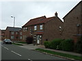
St Augustine Road, Lincoln
Modern housing estate on the outskirts of Lincoln.
Image: © JThomas
Taken: 6 Sep 2014
0.15 miles
2
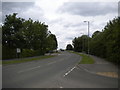
Unnamed road towards Greetwell Road
Image: © J.Hannan-Briggs
Taken: 27 Oct 2012
0.15 miles
3

Lincoln Eastern Bypass
View south from Hawthorn Road footbridge http://www.geograph.org.uk/photo/6725916 on the newly opened Lincoln Eastern Bypass
Image: © Richard Croft
Taken: 6 Jan 2021
0.16 miles
4
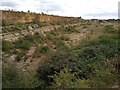
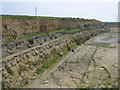
Cliff edge of the former Greetwell Quarry, Lincoln
The exposed limestone rock face on the eastern edge of the former Greetwell Quarry rises above the scrubland below, looking southeastwards from a public footpath in the direction of the Lincoln Eastern Bypass.
This photograph was taken on a mild, overcast morning in late August. Once upon a time the Greetwell Quarry was a site of extensive limestone and ironstone mining, but with the end of operations in 2003 the land has slowly been reclaimed by nature and now forms part of the Greetwell Hollow Nature Reserve, a Site of Special Scientific Interest.
As a vacant plot of land the site has drawn the attention of local councils and housing developers, and along the top of the cliff is metal fencing that marks the boundary of the Greetwell Fields residential development of up to 350 new homes. If local news reporting is to be believed, the building of a new estate within the quarry itself has also been proposed!
For a similar view from 2006, please see Image by Matthew Smith.
Image: © Jonathon Pile
Taken: 29 Aug 2023
0.17 miles
5
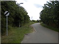
Lane to Greetwell off St Augustine Road, Glebe Park
Image: © Richard Vince
Taken: 16 Jun 2018
0.18 miles
6
Houses on St Augustine Road, Lincoln
Modern housing estate on the outskirts of Lincoln.
Image: © JThomas
Taken: 6 Sep 2014
0.18 miles
7
Stone Quarry
Tucked away just behind Lincoln's industrial estates is this defunct stone quarry. Its size really has to be seen to be believed and it almost feels like your walking through a desert.
Image: © Matthew Smith
Taken: 6 Jun 2006
0.19 miles
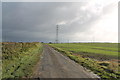
8
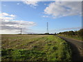
Power lines crossing a lane near Greetwell
The lane does not appear to have a name.
Image: © Jonathan Thacker
Taken: 5 Oct 2016
0.19 miles
9
North end of St Augustine Road, Glebe Park
Looking towards Hawthorn Lane.
Image: © Richard Vince
Taken: 16 Jun 2018
0.19 miles
10
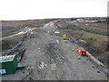
Lincoln eastern bypass under construction
The A15 Lincoln Eastern Bypass under construction. Built as a single carriageway road between the A15/A158 roundabout to the North and a new roundabout at the A15 Sleaford Road to the South with 3 new roundabouts in between, 1 limited access junction. Due to open August 2020.
Image: © Thoma
Taken: 8 Mar 2020
0.20 miles