IMAGES TAKEN NEAR TO
Sellars Way, LN2 2GW
Introduction
This page details the photographs taken nearby to Sellars Way, LN2 2GW by members of the Geograph project.
The Geograph project started in 2005 with the aim of publishing, organising and preserving representative images for every square kilometre of Great Britain, Ireland and the Isle of Man.

There are currently over 7.5m images from over14,400 individuals and you can help contribute to the project by visiting https://www.geograph.org.uk
Image Map
Images are licensed for reuse under creativecommons.org/licenses/by-sa/2.0
Notes
- Clicking on the map will re-center to the selected point.
- The higher the marker number, the further away the image location is from the centre of the postcode.
Image Listing (3 Images Found)
Images are licensed for reuse under creativecommons.org/licenses/by-sa/2.0
Image
Details
Distance
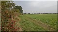
1
Entering Nettleham on path from Scothern
Image: © Chris Morgan
Taken: 29 Sep 2014
0.05 miles
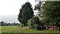
2
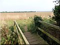
Where's the path?
Beyond this bridge over a field drain the public footpath has not yet been reinstated after ploughing, making navigation more difficult and walking more tiring!
Image: © Graham Hogg
Taken: 29 Sep 2014
0.19 miles