IMAGES TAKEN NEAR TO
Newport, LINCOLN, LN1 3DD
Introduction
This page details the photographs taken nearby to Newport, LN1 3DD by members of the Geograph project.
The Geograph project started in 2005 with the aim of publishing, organising and preserving representative images for every square kilometre of Great Britain, Ireland and the Isle of Man.

There are currently over 7.5m images from over14,400 individuals and you can help contribute to the project by visiting https://www.geograph.org.uk
Image Map
Images are licensed for reuse under creativecommons.org/licenses/by-sa/2.0
Notes
- Clicking on the map will re-center to the selected point.
- The higher the marker number, the further away the image location is from the centre of the postcode.
Image Listing (2726 Images Found)
Images are licensed for reuse under creativecommons.org/licenses/by-sa/2.0
Image
Details
Distance
1

Old Boundary Marker
Municipal Boundary Marker on the east side of the road against the front garden wall of a house 15m north of the Newport Arch, Lincoln, showing a coat of arms. Grade II Listed https://historicengland.org.uk/listing/the-list/list-entry/1388725.
Milestone Society National ID: LI_LIN04pb
Image: © D Garside
Taken: 24 Nov 2019
0.00 miles
2

Newport Arch
3rd Century Roman Gateway to the upper city of Lindum Colonia
Image: © Richard Croft
Taken: 11 Feb 2008
0.00 miles
3
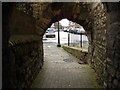
Bailgate Through Newport Arch
View of Bailgate, looking south through the pedestrian tunnel of Newport Arch
Image: © Paul Allison
Taken: 29 Jan 2006
0.00 miles
4
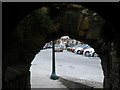
Roman pedestrian arch - Lincoln
The view from the Roman pedestrian tunnel arch into the historic area of Lincoln. This small arch is east side of the larger Roman traffic arch, only the inner large arch remains, the outer large arch was demolished in the 1700s. There was another Roman pedestrian walkway on the west side of the main traffic arch, long since gone in the dust of time.
Image: © Tom Howard
Taken: 1 Aug 2010
0.00 miles
5

Electricity sub-station, Church Lane, Lincoln
Built about 1930 and one of only two surviving examples from Lincoln's early electricity system. An exterior wall clock was functioning here until early in 21st century. Power was probably fed from the Clayton and Shuttleworth power station, purchased by the City Council in 1917 and later the Spa Road Power Station built between 1945 and 1948 and demolished 1989/1990. A free-standing urinal had been put there as early as 1870, but with no underground sewage disposal and its removal was planned in 1891. The current roofless ‘gents’ appears to be built with Lincoln Albion type bricks of around 1912.
Image: © Jo and Steve Turner
Taken: 22 Mar 2014
0.00 miles
6

Former home of the City Police and City Fire Engine in Church Lane, Lincoln
See also Image
Image: © Chris
Taken: 12 Sep 2015
0.01 miles
7

Former home of the City Police and City Fire Engine in Church Lane, Lincoln: detail
Date and crest. See Image
Image: © Chris
Taken: 12 Sep 2015
0.01 miles
8
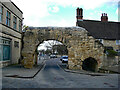
Lincoln : Newport Arch, Bailgate
Grade I listed gateway - https://historicengland.org.uk/listing/the-list/list-entry/1388450?section=official-list-entry
Image: © Jim Osley
Taken: 24 Mar 2024
0.01 miles
9

The Newport Arch
One a gateway into the Roman city of Lincoln, the only Roman gateway in Britain open to traffic and a national treasure.
Image]
Image: © Ashley Dace
Taken: 11 Dec 2010
0.01 miles
10
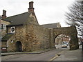
The Newport Arch
The Roman North Gate into the city.
Image: © Jonathan Thacker
Taken: 15 Jan 2011
0.01 miles