IMAGES TAKEN NEAR TO
Hogsthorpe Road, ALFORD, LN13 9SE
Introduction
This page details the photographs taken nearby to Hogsthorpe Road, LN13 9SE by members of the Geograph project.
The Geograph project started in 2005 with the aim of publishing, organising and preserving representative images for every square kilometre of Great Britain, Ireland and the Isle of Man.

There are currently over 7.5m images from over14,400 individuals and you can help contribute to the project by visiting https://www.geograph.org.uk
Image Map
Images are licensed for reuse under creativecommons.org/licenses/by-sa/2.0
Notes
- Clicking on the map will re-center to the selected point.
- The higher the marker number, the further away the image location is from the centre of the postcode.
Image Listing (18 Images Found)
Images are licensed for reuse under creativecommons.org/licenses/by-sa/2.0
Image
Details
Distance
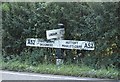
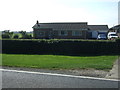
1
Entering Mumby
Heading north west on the A52.
Image: © JThomas
Taken: 11 Sep 2015
0.03 miles
7
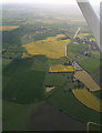
Cumberworth and Mumby: aerial 2015
The two villages separated by Main Drain. Mickleberry Hill at the bottom.
Image: © Chris
Taken: 20 May 2015
0.15 miles
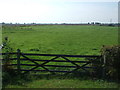
8
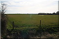
Oh dear, not another blocked footpath: at Mumby
See also Image
A ditch and sturdy barbed wire fence bar the way. Needless to say there is no footpath signpost either. Best forgotten about, eh?
This is an area richly served with footpaths. However most of them are not signposted, and many are impossible to find or have been fenced over. I have complained about a path near here after a previous walk (or planned walk), only to be told it was a low priority path. I was not even given a date by which the problem would be fixed, and it still isn't.
Image: © Chris
Taken: 22 Mar 2015
0.16 miles
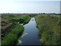
9
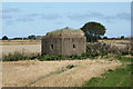
Pillbox by Main Drain
WW2 pillbox near Mumby http://www.geograph.org.uk/photo/2051758
Image: © Richard Croft
Taken: 3 Sep 2010
0.18 miles