IMAGES TAKEN NEAR TO
John Smith Close, ALFORD, LN13 9NZ
Introduction
This page details the photographs taken nearby to John Smith Close, LN13 9NZ by members of the Geograph project.
The Geograph project started in 2005 with the aim of publishing, organising and preserving representative images for every square kilometre of Great Britain, Ireland and the Isle of Man.

There are currently over 7.5m images from over14,400 individuals and you can help contribute to the project by visiting https://www.geograph.org.uk
Image Map (Loading...)


Getting Data...Please wait
Leaflet Map data © OpenStreetMap
Images are licensed for reuse under creativecommons.org/licenses/by-sa/2.0
Notes
- Clicking on the map will re-center to the selected point.
- The higher the marker number, the further away the image location is from the centre of the postcode.
Image Listing (46 Images Found)
Images are licensed for reuse under creativecommons.org/licenses/by-sa/2.0
Image
Details
Distance
1
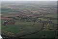
Willoughby, Dam Close and disused railway: aerial 2017
Image: © Chris
Taken: 4 Mar 2017
0.03 miles
2
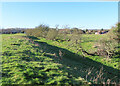
Dam Close
Dam Close is a scheduled ancient monument consisting of an earth bank enclosing an area of level ground and flanked by a moat. There have been various theories as to why it was built, but the latest thinking is that it is a mediaeval market place.
Image: © Anne Burgess
Taken: 2 Jan 2025
0.07 miles
3
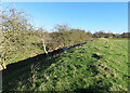
Dam Close
Dam Close is a scheduled ancient monument consisting of an earth bank enclosing an area of level ground and flanked by a moat. There have been various theories as to why it was built, but the latest thinking is that it is a mediaeval market place.
Image: © Anne Burgess
Taken: 2 Jan 2025
0.07 miles
4

Willoughby Branch line: station house
Most of the Branch Line is now a Nature Reserve. See http://microsites.lincolnshire.gov.uk/countryside/visiting-the-countryside/nature-reserves/local-nature-reserves/willoughby-branch-line/41417.article
Image: © Chris
Taken: 17 Jun 2014
0.08 miles
5
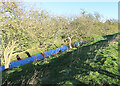
Moat at Dam Close
This is part of the moat alongside Dam Close, a scheduled ancient monument consisting of an earth bank enclosing an area of level ground and flanked by a moat. There have been various theories as to why it was built, but the latest thinking is that it is a mediaeval market place.
Image: © Anne Burgess
Taken: 2 Jan 2025
0.08 miles
6

Willoughby Station
Former trackbed by Willoughby Station looking south
Image: © Richard Croft
Taken: 3 Sep 2010
0.08 miles
7

Visit to Dam Close, Willoughby, January 2025 (2)
A small group visits the impressive earthworks (in the background), which were originally thought to be the remains of a Roman or Danish camp. However it is now thought to be the remains of a probable medieval enclosure or ringwork. A function of the earthwork as a stock enclosure has been suggested.
See: https://www.heritagegateway.org.uk/Gateway/Results_Single.aspx?uid=MLI42004&resourceID=1006
For aerial shot see Image
Image: © Chris
Taken: 2 Jan 2025
0.10 miles

9

Dam Close, Willoughby
"Dam Close" appears to be two fortified enclosures with entrances on the north and south sides. The banks have been reduced in height to the north west and end in a small hollow and subsidiary enclosure. To the south east the area has been levelled. See http://www.heritagegateway.org.uk/Gateway/Results_Single.aspx?uid=MLI42004&resourceID=1006
I first spotted this enormous and spectacular medieval site at Willoughby from the air (Image). Incredibly I had a job to find anyone in Willoughby who knew it was there.
Image: © Chris
Taken: 17 Jun 2014
0.10 miles
10

Willoughby track
Track leading from Station Road at Willoughby
Image: © Richard Croft
Taken: 3 Sep 2010
0.10 miles