IMAGES TAKEN NEAR TO
White Pit Way, ALFORD, LN13 0AZ
Introduction
This page details the photographs taken nearby to White Pit Way, LN13 0AZ by members of the Geograph project.
The Geograph project started in 2005 with the aim of publishing, organising and preserving representative images for every square kilometre of Great Britain, Ireland and the Isle of Man.

There are currently over 7.5m images from over14,400 individuals and you can help contribute to the project by visiting https://www.geograph.org.uk
Image Map
Images are licensed for reuse under creativecommons.org/licenses/by-sa/2.0
Notes
- Clicking on the map will re-center to the selected point.
- The higher the marker number, the further away the image location is from the centre of the postcode.
Image Listing (18 Images Found)
Images are licensed for reuse under creativecommons.org/licenses/by-sa/2.0
Image
Details
Distance
1
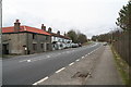
Mill Row, by the A16
At the bottom of the hill, so presumably the mill must have been a water mill, though there seems to be no stream.
Image: © Chris
Taken: 22 Feb 2014
0.04 miles
2
Mill Row, by the A16
At the bottom of the hill, so presumably the mill must have been a water mill, though there seems to be no stream.
Image: © Chris
Taken: 22 Feb 2014
0.05 miles
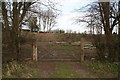
3
White Pit Way alongside the A16
White Pit is the area marked on the map here. There is a small pit to the south of Pinfold Lane, and several other (chalk pits) in the area.
Image: © Chris
Taken: 22 Feb 2014
0.08 miles
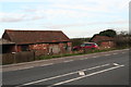
4
Small disused pit, but not white
This old pit is on the south side of an area named "White Pit", and the best I could find in the immediate area, though there are big, impressive chalk pits close by. Perhaps they are too recent to have given their name to part of a village.
Image: © Chris
Taken: 22 Feb 2014
0.11 miles
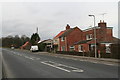
6
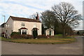
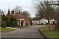
House and former cafe on the corner of Pinfold Lane
The little building was used as a cafe for about eight years, finishing in about 2004.
Image: © Chris
Taken: 22 Feb 2014
0.14 miles
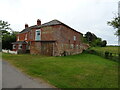
8
White Pit, Swaby
The cottage on the right is partly built of clunch (chalk) presumably from the pit after which this hamlet is named.
Image: © Jonathan Thacker
Taken: 13 Nov 2010
0.17 miles
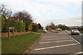
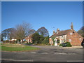
9
Houses and post box on the corner of White Pit Way and Pinfold Lane
Image: © Chris
Taken: 22 Feb 2014
0.17 miles
10
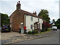
Post Box Cottage on Whitepit Way, Swaby
Showing position of Postbox No. LN13 885.
See Image] for postbox.
Image: © JThomas
Taken: 4 Jun 2020
0.17 miles