IMAGES TAKEN NEAR TO
The Oval, LINCOLN, LN1 2ZT
Introduction
This page details the photographs taken nearby to The Oval, LN1 2ZT by members of the Geograph project.
The Geograph project started in 2005 with the aim of publishing, organising and preserving representative images for every square kilometre of Great Britain, Ireland and the Isle of Man.

There are currently over 7.5m images from over14,400 individuals and you can help contribute to the project by visiting https://www.geograph.org.uk
Image Map
Images are licensed for reuse under creativecommons.org/licenses/by-sa/2.0
Notes
- Clicking on the map will re-center to the selected point.
- The higher the marker number, the further away the image location is from the centre of the postcode.
Image Listing (83 Images Found)
Images are licensed for reuse under creativecommons.org/licenses/by-sa/2.0
Image
Details
Distance
1
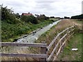
Sewer Drain at Torksey Lock
Such a lovely name for a watercourse!
Image: © Graham Hogg
Taken: 17 Aug 2018
0.05 miles
2
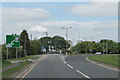
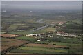
Junction of A156 and A1133
Cottam Power Station looms behind the trees.
Image: © J.Hannan-Briggs
Taken: 2 Jun 2013
0.06 miles
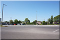
7

The Wheelhouse
Restaurant and bar by the Fossdyke at Torksey Lock
Image: © Richard Croft
Taken: 11 Feb 2012
0.08 miles
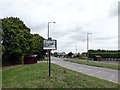
8
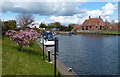
Moorings at Torksey Lock
At the western end of the eleven and a quarter mile long Fossdyke Canal, near Torksey Junction where it joins the River Trent.
Image: © Mat Fascione
Taken: 30 Apr 2016
0.08 miles

