IMAGES TAKEN NEAR TO
Saxilby Road, LINCOLN, LN1 2AA
Introduction
This page details the photographs taken nearby to Saxilby Road, LN1 2AA by members of the Geograph project.
The Geograph project started in 2005 with the aim of publishing, organising and preserving representative images for every square kilometre of Great Britain, Ireland and the Isle of Man.

There are currently over 7.5m images from over14,400 individuals and you can help contribute to the project by visiting https://www.geograph.org.uk
Image Map (Loading...)


Getting Data...Please wait
Leaflet Map data © OpenStreetMap
Images are licensed for reuse under creativecommons.org/licenses/by-sa/2.0
Notes
- Clicking on the map will re-center to the selected point.
- The higher the marker number, the further away the image location is from the centre of the postcode.
Image Listing (16 Images Found)
Images are licensed for reuse under creativecommons.org/licenses/by-sa/2.0
Image
Details
Distance
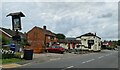
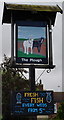
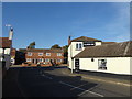
3
The village hall at Sturton by Stow
Stow with its magnificent church is much smaller than Sturton by Stow a mile to the south. This view looks along the Roman road (now the A1500 Tillbridge Road) just past the crossroads at the centre of the village. There is a general store, as well as the Plough Inn and other facilities. The village hall is just across the road here.
Image: © Marathon
Taken: 29 Sep 2018
0.22 miles
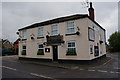
4
Tillbridge Road, Sturton by Stow
Stow with its magnificent church is much smaller than Sturton by Stow a mile to the south. This view looks along the Roman road (now the A1500 Tillbridge Road) just past the crossroads at the centre of the village. There is a general store, as well as the Plough Inn, the sign for which can just be seen on the right, and other facilities. The village hall is across the road on the left.
Image: © Marathon
Taken: 29 Sep 2018
0.22 miles
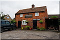
8
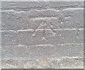
Ordnance Survey Cut Mark
This OS cut mark can be found on the north face of The Plough. It marks a point 14.109m above mean sea level.
Image: © Adrian Dust
Taken: 26 Jul 2017
0.23 miles
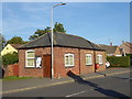
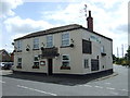
9
Sturton by Stow
Stow with its magnificent church is much smaller than Sturton by Stow a mile to the south. This looks along Saxilby Road to the centre of Sturton by Stow where the Roman road (now the A1500) crosses over. There is a general store, which can just be seen to the left, as well as the Plough Inn and other facilities.
Image: © Marathon
Taken: 29 Sep 2018
0.23 miles
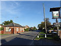
10
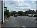
Tillbridge Road (A1500), Sturton by Stow
Heading east.
Image: © JThomas
Taken: 29 Jun 2013
0.23 miles