IMAGES TAKEN NEAR TO
Tuplin Road, MABLETHORPE, LN12 1FE
Introduction
This page details the photographs taken nearby to Tuplin Road, LN12 1FE by members of the Geograph project.
The Geograph project started in 2005 with the aim of publishing, organising and preserving representative images for every square kilometre of Great Britain, Ireland and the Isle of Man.

There are currently over 7.5m images from over14,400 individuals and you can help contribute to the project by visiting https://www.geograph.org.uk
Image Map
Images are licensed for reuse under creativecommons.org/licenses/by-sa/2.0
Notes
- Clicking on the map will re-center to the selected point.
- The higher the marker number, the further away the image location is from the centre of the postcode.
Image Listing (15 Images Found)
Images are licensed for reuse under creativecommons.org/licenses/by-sa/2.0
Image
Details
Distance
4
Bud (Brian) Shields MBE
As a 22 year old he was caught up in the 1953 floods rescuing a woman from her house and as a councillor served on flood committees for 30 years.
Image: © John M
Taken: 20 Apr 2018
0.17 miles
7
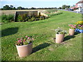
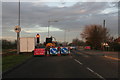
Roadside floral display
Seen on the corner of the crossroads where the busy Alford Road (A1104) crosses Golf Road and Church Road, this display really brightens up the scene. Golf Road is to the right here.
Image: © Marathon
Taken: 7 Oct 2012
0.18 miles
8
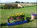
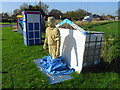
A colourful road junction
Seen on the corner of the crossroads where the busy Alford Road (A1104) crosses Golf Road and Church Road, this display really brightens up the scene. Full marks to whoever was responsible.
Image: © Marathon
Taken: 7 Oct 2012
0.19 miles
9
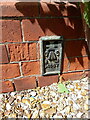
OS Flush Bracket G4687, Mablethorpe
G4687 lies on the roadside wall of the former County Primary School, although the building appears redundant at present. It was recorded during the 3rd Geodetic Levelling survey in the late 1950s or early 1960s at 2.07m above Ordnance Datum Newlyn.
Image: © Richard Law
Taken: 23 May 2023
0.21 miles
10
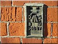
Ordnance Survey Flush Bracket G4687
This bracket can be found on the roadside wall of a nursery/school building in Mablethorpe. The benchmark height is recorded as being 2.07 metres above sea level.
For more detail see : https://www.bench-marks.org.uk/bm13502
Image: © Peter Wood
Taken: 26 Feb 2019
0.21 miles