IMAGES TAKEN NEAR TO
West Parade, LINCOLN, LN1 1LY
Introduction
This page details the photographs taken nearby to West Parade, LN1 1LY by members of the Geograph project.
The Geograph project started in 2005 with the aim of publishing, organising and preserving representative images for every square kilometre of Great Britain, Ireland and the Isle of Man.

There are currently over 7.5m images from over14,400 individuals and you can help contribute to the project by visiting https://www.geograph.org.uk
Image Map (Loading...)


Getting Data...Please wait
Leaflet Map data © OpenStreetMap
Images are licensed for reuse under creativecommons.org/licenses/by-sa/2.0
Notes
- Clicking on the map will re-center to the selected point.
- The higher the marker number, the further away the image location is from the centre of the postcode.
Image Listing (84 Images Found)
Images are licensed for reuse under creativecommons.org/licenses/by-sa/2.0
Image
Details
Distance
1
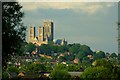
Yarborough Hill
Housing climbs the hillside dominated by the West front of the Minster in the background.
Image: © Donnylad
Taken: 23 Jun 2007
0.04 miles
2
Lincoln, 3 Albert Crescent
There is a cut mark on the brick pillar separating the entrance of No.3 from a passage to the rear. See https://www.geograph.org.uk/photo/6132058 for a closer view and https://www.bench-marks.org.uk/bm106981 for details.
Image: © Brian Westlake
Taken: 24 Apr 2019
0.05 miles
3
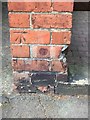
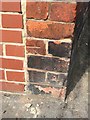
Cut Mark: Lincoln, 3 Albert Crescent
Cut mark on the brick pillar separating the entrance of No.3 from a passage to the rear. See https://www.geograph.org.uk/photo/6132060 for a wider view and https://www.bench-marks.org.uk/bm106981 for details.
Image: © Brian Westlake
Taken: 24 Apr 2019
0.05 miles
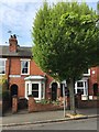
4
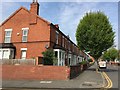
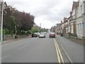
West Parade - viewed from Gresham Street
Image: © Betty Longbottom
Taken: 5 Sep 2009
0.07 miles
5
Cut Mark: Lincoln, Richmond Road
Cut bench mark on the wall angle at the junction of Richmond Road and Hampton Street. See https://www.geograph.org.uk/photo/6132067 for a wider view and https://www.bench-marks.org.uk/bm106980 for details.
Image: © Brian Westlake
Taken: 24 Apr 2019
0.08 miles
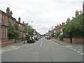
6
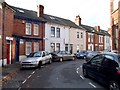
The Junction of Richmond Road and Hampton Street
There is a cut bench mark on the wall angle at the junction of Richmond Road and Hampton Street. See https://www.geograph.org.uk/photo/6132064 for a closer view and https://www.bench-marks.org.uk/bm106980 for details.
Image: © Brian Westlake
Taken: 24 Apr 2019
0.08 miles
8
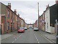
Ely Street, Lincoln
This cul-de-sac is more in this square than the map gives it credit for. The street backs onto a large area of common land, part of which was a race course.
Image: © Dave Hitchborne
Taken: 27 Oct 2007
0.09 miles
9
West Parade - viewed from Gresham Street
Image: © Betty Longbottom
Taken: 5 Sep 2009
0.10 miles
10
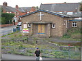
Former Church on West Parade
No longer serving the community - would make a good community hall for local students and residents ?? In better days only 12 months ago Image]
Image: © Michael Westley
Taken: 26 Sep 2010
0.10 miles