IMAGES TAKEN NEAR TO
Tathwell, LOUTH, LN11 9SA
Introduction
This page details the photographs taken nearby to LN11 9SA by members of the Geograph project.
The Geograph project started in 2005 with the aim of publishing, organising and preserving representative images for every square kilometre of Great Britain, Ireland and the Isle of Man.

There are currently over 7.5m images from over14,400 individuals and you can help contribute to the project by visiting https://www.geograph.org.uk
Image Map
Images are licensed for reuse under creativecommons.org/licenses/by-sa/2.0
Notes
- Clicking on the map will re-center to the selected point.
- The higher the marker number, the further away the image location is from the centre of the postcode.
Image Listing (6 Images Found)
Images are licensed for reuse under creativecommons.org/licenses/by-sa/2.0
Image
Details
Distance
1

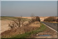
Dovendale, farm entrance
Looking towards Stonepit Covert on the road into Tathwell.
Image: © Chris
Taken: 12 Mar 2014
0.08 miles

3

A153 SW of Louth, looking northwards: aerial 2014
In the foreground is Dovendale.
Image: © Chris
Taken: 10 Feb 2014
0.15 miles
5
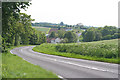
Dovendale near Louth, Lincolnshire
Horncastle Road (A153) dips down into Dovendale before rising towards Cadwell Park Image
Image: © Kate Jewell
Taken: 6 Jun 2006
0.19 miles
6
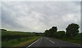
Rolling chalk hills from the A153
Looking towards Dovendale and Louth.
Image: © Chris
Taken: 12 Mar 2014
0.24 miles