IMAGES TAKEN NEAR TO
Horncastle Road, LOUTH, LN11 9RZ
Introduction
This page details the photographs taken nearby to Horncastle Road, LN11 9RZ by members of the Geograph project.
The Geograph project started in 2005 with the aim of publishing, organising and preserving representative images for every square kilometre of Great Britain, Ireland and the Isle of Man.

There are currently over 7.5m images from over14,400 individuals and you can help contribute to the project by visiting https://www.geograph.org.uk
Image Map
Images are licensed for reuse under creativecommons.org/licenses/by-sa/2.0
Notes
- Clicking on the map will re-center to the selected point.
- The higher the marker number, the further away the image location is from the centre of the postcode.
Image Listing (12 Images Found)
Images are licensed for reuse under creativecommons.org/licenses/by-sa/2.0
Image
Details
Distance
1
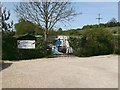
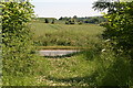
Maltby Springs
Selling everything for the pond owner - including the fish!! The spring is to the right of the photograph, and another similar feature is to be found near Raithby.
Image: © John Beal
Taken: 26 Apr 2007
0.01 miles
2
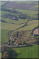
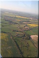
Maltby to Raithby down the River Lud: aerial 2015
See also "Raithby towards Hallington, down the River Lud: aerial 2015" Image] and "Tathwell through Maltby, down the River Lud: aerial 2015" Image
Fishery in the foreground by the river.
Grass fields to the left have marks related to old field systems (not sure if this is part of Maltby Medieval Village, which is not shown on the OS map).
Raithby and old field systems at the top: see Image], Image], Image and Image
Various becks and springs go to make up the River Lud. Technically, I have read, it is not called the Lud until Hallington Beck joins Welton Beck (from beyond Welton Springs and Little Welton), i.e. to the east of Hubbards Hills. Meanwhile the beck in this picture has yet to join another Hallington Beck, which emanates from west of Withcall.
Image: © Chris
Taken: 21 Apr 2015
0.02 miles
3
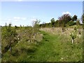
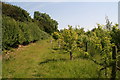
Young woodland
For the final hundred yards or so before the A153 is reached the footpath passes through this very young woodland.
Image: © John Beal
Taken: 26 Apr 2007
0.03 miles
4
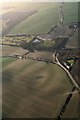
Down the A153 to Maltby Springs, with Tathwell left: aerial 2018
Image: © Chris
Taken: 7 Jan 2018
0.04 miles
5
Footpath from Maltby arrives at the Horncasle Road
Image: © Chris
Taken: 9 Jul 2013
0.07 miles
6
Tathwell through Maltby, down the River Lud: aerial 2015
Various becks and springs go to make up the River Lud. Technically, I have read, it is not called the Lud until Hallington Beck joins Welton Beck (from beyond Welton Springs and Little Welton), i.e. to the east of Hubbards Hills. Meanwhile the beck in this picture has yet to join another Hallington Beck, which emanates from west of Withcall.
Image: © Chris
Taken: 21 Apr 2015
0.07 miles
7
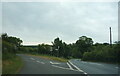
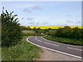
Junction on the A153 near Raithby
Road to Tathwell on the left.
Image: © JThomas
Taken: 4 Jun 2020
0.09 miles
9
A153, Maltby
Despite appearances this is a very busy road, and the short walk from the end of the Raithby footpath proved to be a very dangerous experience! Maltby is a very small hamlet comprising (seemingly) one house and a storage facility!
Image: © John Beal
Taken: 26 Apr 2007
0.18 miles
10
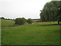
The valley between Raithby and Maltby
Drained by one of the tributaries of the River Lud.
Image: © Jonathan Thacker
Taken: 21 Aug 2012
0.22 miles