IMAGES TAKEN NEAR TO
Donington-on-Bain, LOUTH, LN11 9RH
Introduction
This page details the photographs taken nearby to LN11 9RH by members of the Geograph project.
The Geograph project started in 2005 with the aim of publishing, organising and preserving representative images for every square kilometre of Great Britain, Ireland and the Isle of Man.

There are currently over 7.5m images from over14,400 individuals and you can help contribute to the project by visiting https://www.geograph.org.uk
Image Map
Images are licensed for reuse under creativecommons.org/licenses/by-sa/2.0
Notes
- Clicking on the map will re-center to the selected point.
- The higher the marker number, the further away the image location is from the centre of the postcode.
Image Listing (31 Images Found)
Images are licensed for reuse under creativecommons.org/licenses/by-sa/2.0
Image
Details
Distance
1

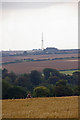
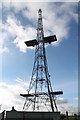
Chain Home Radar Tower
A description can be found at http://www.britishlistedbuildings.co.uk/en-463018-chain-home-transmitter-tower-at-tf-2568-
Image: © Jonathan Thacker
Taken: 18 Jun 2010
0.01 miles
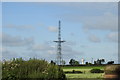
2
CH Radar Tower, Stenigot
Photo taken from Grim's Mound near Grimblethorpe.
Image: © David Wright
Taken: 8 Sep 2007
0.01 miles
3

The Folly
House called The Folly, seen from the Unadopted County Road near Stenigot
Image: © Richard Croft
Taken: 12 Jun 2014
0.01 miles
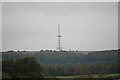
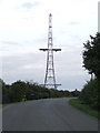
4
Once part of Chain Home radar
The mast was part of the Chain Home Radar Station at RAF Stenigot.
RAF Stenigot was a Second World War radar station situated near Donington on Bain, Lincolnshire.
It was part of the Chain Home radar network, intended to provide long range early warning for raids from Luftflotte 5 and the northern elements of Luftflotte 2 along the approaches to Sheffield and Nottingham and the central Midlands.
After the Second World War, the site was retained as part of the Chain Home network. In 1959 it was upgraded to a communications relay site as part of the ACE High programme, which involved adding four tropospheric scatter dishes. These now lie abandoned on the site.
The site was decommissioned in the late 1980s and was mostly demolished by 1996.
The radar tower and Transmitter Block are Grade II listed structures
Image: © Adrian S Pye
Taken: 20 Jun 2020
0.02 miles
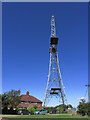
5
RAF Stenigot
The last surviving Chain Home radar tower from WW2.
As seen from the same location as Image
Image: © Bob Harvey
Taken: 19 Oct 2016
0.02 miles
7
Chain Home Radar Mast
Grade II listed.
At Former RAF Stenigot. See http://en.wikipedia.org/wiki/RAF_Stenigot
Image: © J.Hannan-Briggs
Taken: 11 Nov 2012
0.02 miles
8
Former Chain Home Mast
A former chain home mast at Manor Hill Stenigot, Lincolnshire for more info on the site see http://www.subbrit.org.uk/rsg/sites/s/stenigot/ http://en.wikipedia.org/wiki/RAF_Stenigot
Image: © Keith Evans
Taken: 17 Sep 2012
0.02 miles
9
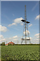
Chain Home transmitter mast
Grade II listed, 350 feet high transmitter mast at the former RAF Stenigot site on the Wolds http://www.subbrit.org.uk/rsg/sites/s/stenigot/
Image: © Richard Croft
Taken: 12 Jun 2014
0.02 miles
10
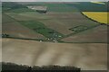
Stenigot Chain Home transmitter mast: aerial 2022
See: Image
Image: © Chris
Taken: 28 Apr 2022
0.02 miles