IMAGES TAKEN NEAR TO
Priory Close, LOUTH, LN11 9AS
Introduction
This page details the photographs taken nearby to Priory Close, LN11 9AS by members of the Geograph project.
The Geograph project started in 2005 with the aim of publishing, organising and preserving representative images for every square kilometre of Great Britain, Ireland and the Isle of Man.

There are currently over 7.5m images from over14,400 individuals and you can help contribute to the project by visiting https://www.geograph.org.uk
Image Map (Loading...)


Getting Data...Please wait
Leaflet Map data © OpenStreetMap
Images are licensed for reuse under creativecommons.org/licenses/by-sa/2.0
Notes
- Clicking on the map will re-center to the selected point.
- The higher the marker number, the further away the image location is from the centre of the postcode.
Image Listing (90 Images Found)
Images are licensed for reuse under creativecommons.org/licenses/by-sa/2.0
Image
Details
Distance
1
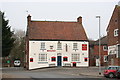
The Woolpack
A fine hostelry in Louth by the canal, selling Bateman's beers and good food
Image: © Richard Croft
Taken: 7 Mar 2006
0.02 miles
2
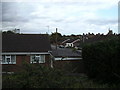
Where once there was a railway
This modern housing estate is situated on land that once was part of the trackbed of the East Lincolnshire Railway.
Image: © John Beal
Taken: 28 Aug 2007
0.04 miles
3
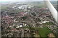
Northwards along the (disused) railway through Louth: aerial 2018
Image: © Chris
Taken: 13 Mar 2018
0.07 miles
4
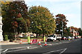
Eastgate roadworks
"Please find alternative route" - as if it were that easy!
This is a view down Eastgate eastwards from the war memorial, past the Alms Houses to the former Police Station.
Image: © Chris
Taken: 10 Oct 2012
0.07 miles
5
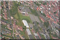
Monks Dyke School area of Louth, aerial 2007
Centre is the school, with the old bus depot (and buses) near the bottom right edge.
Image: © Chris
Taken: 5 Aug 2007
0.08 miles
6
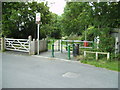
Entrance to Railway Walk
This footpath follows the trackbed of the former East Lincolnshire Railway as far as Stewton Lane, close to the junction with the Mablethorpe line.
Image: © John Beal
Taken: 28 Aug 2007
0.09 miles
7
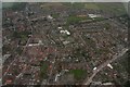
Eastgate, Eastfield Road and Louth southeast: aerial 2018
Image: © Chris
Taken: 13 Mar 2018
0.09 miles
8
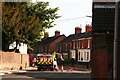
East down Eastgate
The Priory Hotel garden wall on the left, three differing terraces if Victorian houses on the right.
And an airborne road cone!
Image: © Chris
Taken: 10 Oct 2012
0.10 miles
9
250 Eastgate Louth
250 and its adjoining 252 Eastgate are Grade II Listed semi-detached villas of 1826 with very good detailing.
Image: © Jo and Steve Turner
Taken: Unknown
0.10 miles
10

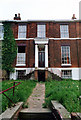
Houses on Eastgate, Louth
These handsome semi-detached villas were built in 1826 with minor alterations in the 20th century. They are grade II listed.
Image: © Stephen McKay
Taken: 6 May 2025
0.10 miles