IMAGES TAKEN NEAR TO
Chapel Lane, LOUTH, LN11 8HQ
Introduction
This page details the photographs taken nearby to Chapel Lane, LN11 8HQ by members of the Geograph project.
The Geograph project started in 2005 with the aim of publishing, organising and preserving representative images for every square kilometre of Great Britain, Ireland and the Isle of Man.

There are currently over 7.5m images from over14,400 individuals and you can help contribute to the project by visiting https://www.geograph.org.uk
Image Map (Loading...)


Getting Data...Please wait
Leaflet Map data © OpenStreetMap
Images are licensed for reuse under creativecommons.org/licenses/by-sa/2.0
Notes
- Clicking on the map will re-center to the selected point.
- The higher the marker number, the further away the image location is from the centre of the postcode.
Image Listing (14 Images Found)
Images are licensed for reuse under creativecommons.org/licenses/by-sa/2.0
Image
Details
Distance
1
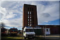
"Charterhouse", former R.A.F. Manby
This building, which was once an officers' club, has been allowed to become derelict.
Image: © Chris
Taken: 1 Jan 2013
0.11 miles
2
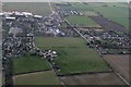
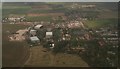
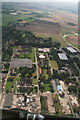
Ridge and furrow and enclosure marks east of Manby: aerial 2018
Image: © Chris
Taken: 7 Feb 2018
0.13 miles
3
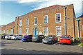
Gibson Hall, the old Station HQ at RAF Manby
Currently being used by The Environment Agency. Inside is a memorial to all the Station Commanders, 1938 - 1971.
Image: © Adrian S Pye
Taken: 29 Aug 2019
0.14 miles
4
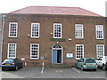
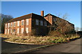
Guy Gibson Hall, Manby
One of the buildings on the old RAF base is known as Guy Gibson Hall, and in it now is the headquarters of Anglian Water Authority and a plaque to one of Manby’s favourite sons.
Image: © John Readman
Taken: 23 Feb 2003
0.14 miles
5
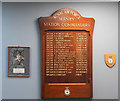
Manby Station Commanders with a picture of Guy Gibson,
Flight Lieutenant Guy Gibson, later Wing Commander of Dam Busters fame made his first "kill" from Manby in 1941.
Image: © Adrian S Pye
Taken: 29 Aug 2019
0.15 miles
6
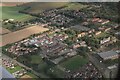
Former RAF Manby and ELDC offices
The old air base, looking south towards Carlton.
The burnt out hangar shown in Image is on the extreme right.
East Lindsey District Council's offices are the building with the grassy quadrangle at the far end.
Image: © Chris
Taken: 7 Sep 2012
0.15 miles
7
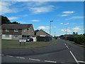
Vampire road Manby
Vampire, venom, javelin etc. Presumably named after various military aircraft?
Image: © Steve Fareham
Taken: 14 Jul 2014
0.15 miles