IMAGES TAKEN NEAR TO
Pleasance Way, LOUTH, LN11 8HJ
Introduction
This page details the photographs taken nearby to Pleasance Way, LN11 8HJ by members of the Geograph project.
The Geograph project started in 2005 with the aim of publishing, organising and preserving representative images for every square kilometre of Great Britain, Ireland and the Isle of Man.

There are currently over 7.5m images from over14,400 individuals and you can help contribute to the project by visiting https://www.geograph.org.uk
Image Map (Loading...)


Getting Data...Please wait
Leaflet Map data © OpenStreetMap
Images are licensed for reuse under creativecommons.org/licenses/by-sa/2.0
Notes
- Clicking on the map will re-center to the selected point.
- The higher the marker number, the further away the image location is from the centre of the postcode.
Image Listing (29 Images Found)
Images are licensed for reuse under creativecommons.org/licenses/by-sa/2.0
Image
Details
Distance
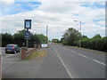
2

Sign for the Lancaster Inn, Manby Middlegate
Image: © JThomas
Taken: 21 Mar 2015
0.06 miles

4
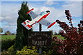
A jet provost model
Serving as a village sign due to the former dominance of RAF Manby. See: Image
Image: © David Lally
Taken: 15 Aug 2021
0.07 miles
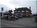
5
The Lancaster Inn
The sign above the door has seen better days.
Image: © David Lally
Taken: 15 Aug 2021
0.07 miles
8
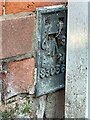
Flush Bracket OSBM S3056: Manby
This flush bracket benchmark is partly hidden by a drain pipe on the frontage of the Co-op shop. See https://www.geograph.org.uk/photo/7004330 for a wider view and https://www.bench-marks.org.uk/bm19337 for details.
Image: © Brian Westlake
Taken: 28 Oct 2021
0.08 miles
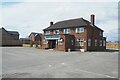
9
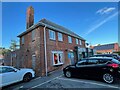
The Co-op Shop in Manby
On the near angle is a flush bracket benchmark partly hidden by a drain pipe on the frontage of the Co-op shop. See https://www.geograph.org.uk/photo/7004327 for a closer view and https://www.bench-marks.org.uk/bm19337 for details.
Image: © Brian Westlake
Taken: 28 Oct 2021
0.08 miles
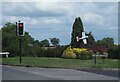
10
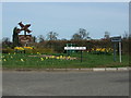
Village signposts Grimoldby and Manby
At junction of B1200 and Carlton Road. Adjacent to the old RAF Station at Manby part of which is now East Lindsey District Council offices.
Image: © Richard Hoare
Taken: 10 Apr 2010
0.08 miles