IMAGES TAKEN NEAR TO
Buddleia Drive, LN11 8FX
Introduction
This page details the photographs taken nearby to Buddleia Drive, LN11 8FX by members of the Geograph project.
The Geograph project started in 2005 with the aim of publishing, organising and preserving representative images for every square kilometre of Great Britain, Ireland and the Isle of Man.

There are currently over 7.5m images from over14,400 individuals and you can help contribute to the project by visiting https://www.geograph.org.uk
Image Map
Images are licensed for reuse under creativecommons.org/licenses/by-sa/2.0
Notes
- Clicking on the map will re-center to the selected point.
- The higher the marker number, the further away the image location is from the centre of the postcode.
Image Listing (19 Images Found)
Images are licensed for reuse under creativecommons.org/licenses/by-sa/2.0
Image
Details
Distance
1

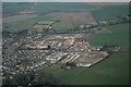
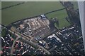
New development on east side of Louth: aerial (2)
Image: © Chris
Taken: 3 Jul 2022
0.02 miles
2

New development on east side of Louth: aerial (1)
Image: © Chris
Taken: 3 Jul 2022
0.04 miles
3
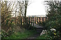
Footpath bridge near Stewton Lane
On the short piece of footpath which follows the disused railway trackbed from Stewton Lane then loops back to Stewton Lane.
Image: © Chris
Taken: 29 Nov 2012
0.17 miles
5
Footpath from Stewton Lane to Stewton Lane
On the short piece of footpath which follows the disused railway trackbed from Stewton Lane then loops back to Stewton Lane.
Image: © Chris
Taken: 29 Nov 2012
0.17 miles
6
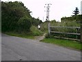
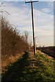
Stewton Lane Level Crossing (site of)
Whilst the crossing has all but disappeared, the electricity poles clearly denote the route of the former railway as it progresses south.
Image: © John Beal
Taken: 28 Aug 2007
0.17 miles
7

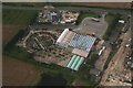
Flooded residential development site off Legbourne Road, Louth (2)
One of the objections to the development was that, lets say, the ground in this area is quickly saturated in the event of rain.
Image: © Chris
Taken: 25 Nov 2022
0.18 miles
8
Flooded residential development site off Legbourne Road, Louth: aerial 2022 (1)
One of the objections to the development was that, lets say, the ground in this area is quickly saturated in the event of rain.
Image: © Chris
Taken: 25 Nov 2022
0.18 miles
9
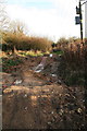
Stewton Lane to Stewton Lane
This short section of footpath continues along the line of the old railway track where it crosses Stewton Lane, then reconnects with Stewton Lane a few hundred metres further on.
Whereas the previous section (see: Image) has a tarmac path, and has had a lot of time and money spent on it, this piece has been left to its own devices, although the piles of mud have been adapted, in a makeshift fashion, for bikes.
Image: © Chris
Taken: 29 Nov 2012
0.19 miles