IMAGES TAKEN NEAR TO
Florence Wright Avenue, LOUTH, LN11 8EJ
Introduction
This page details the photographs taken nearby to Florence Wright Avenue, LN11 8EJ by members of the Geograph project.
The Geograph project started in 2005 with the aim of publishing, organising and preserving representative images for every square kilometre of Great Britain, Ireland and the Isle of Man.

There are currently over 7.5m images from over14,400 individuals and you can help contribute to the project by visiting https://www.geograph.org.uk
Image Map (Loading...)


Getting Data...Please wait
Leaflet Map data © OpenStreetMap
Images are licensed for reuse under creativecommons.org/licenses/by-sa/2.0
Notes
- Clicking on the map will re-center to the selected point.
- The higher the marker number, the further away the image location is from the centre of the postcode.
Image Listing (10 Images Found)
Images are licensed for reuse under creativecommons.org/licenses/by-sa/2.0
Image
Details
Distance
2
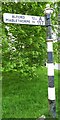
Old Direction Sign - Signpost by the A157, Kenwick Road, Louth Parish
Ball finial - 1 arm; by the A157, in parish of Louth (East Lindsey District), junction of Kenwick Road with Legbourne Road, Louth, on grass verge.
Surveyed
Milestone Society National ID: LI_TF3386
Image: © Milestone Society
Taken: Unknown
0.11 miles
3
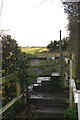
Legbourne Road: a substantial stile
Footpath leads to the old A16.
Image: © Chris
Taken: 29 Nov 2012
0.14 miles
4
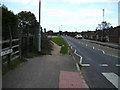
Footpath to Kenwick Road
From the old A16 past the bottom of Linden Walk, shortly after which this photo was taken.
NB. There is apparently no access to it from Linden Walk, which becomes a private drive at the end, where it intersects the path.
Image: © Chris
Taken: 29 Nov 2012
0.17 miles
5

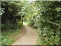
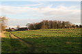
Railway Walk near Stewton Lane
It is difficult to believe that this was once a busy main-line, now strangely silent. It closed in 1970.
Image: © John Beal
Taken: 28 Aug 2007
0.23 miles
6
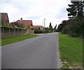
Stewton Lane, Louth
Looking towards the town centre.
Image: © John Beal
Taken: 28 Aug 2007
0.23 miles
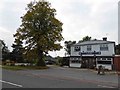
7
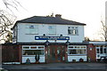
White Horse Inn
A pretty pub on a lovely country road near to the wartime airfield at Manby, a model Lancaster bomber is sited just across the road from the pub at the cross roads.
Image: © Gail Franklin
Taken: 24 Feb 2011
0.23 miles

9
Wood Lane, Louth
Looking south west from the railway walk.
Image: © John Beal
Taken: 28 Aug 2007
0.24 miles