IMAGES TAKEN NEAR TO
Stockwith Drive, LOUTH, LN11 8BN
Introduction
This page details the photographs taken nearby to Stockwith Drive, LN11 8BN by members of the Geograph project.
The Geograph project started in 2005 with the aim of publishing, organising and preserving representative images for every square kilometre of Great Britain, Ireland and the Isle of Man.

There are currently over 7.5m images from over14,400 individuals and you can help contribute to the project by visiting https://www.geograph.org.uk
Image Map (Loading...)


Getting Data...Please wait
Leaflet Map data © OpenStreetMap
Images are licensed for reuse under creativecommons.org/licenses/by-sa/2.0
Notes
- Clicking on the map will re-center to the selected point.
- The higher the marker number, the further away the image location is from the centre of the postcode.
Image Listing (7 Images Found)
Images are licensed for reuse under creativecommons.org/licenses/by-sa/2.0
Image
Details
Distance
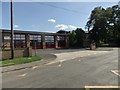
1
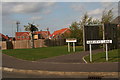
Woodland Corner, Harveys Lane
"The park closes at 9pm".
Corner park on the new estate behind St.Bernard's Avenue.
The tree has some strange new growth on it!
Image: © Chris
Taken: 10 Oct 2012
0.07 miles
2
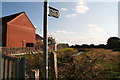
Footpath to Stewton Lane, and the Monks' Dyke
After recent clearing, you can just see the Cistercian monks' dyke as it emerges from its culvert under the St.Bernard's Avenue estate, on its way from St.Helen's Spring in the Gatherums, Louth, to Louth Park Abbey.
The monks cut out the channel to divert the water to their abbey.
Image: © Chris
Taken: 10 Oct 2012
0.11 miles
3
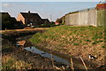
Dreams of fishes past: footpath by the Monks' Dyke
The cat lives in hope!
After recent clearing, you can see the Cistercian monks' dyke as it emerges from its culvert under the St.Bernard's Avenue estate, on its way from St.Helen's Spring in the Gatherums, Louth, to Louth Park Abbey.
The monks cut out the channel to divert the water to their abbey.
The clearing operation has revealed all the junk that has been thrown into the dyke.
Image: © Chris
Taken: 10 Oct 2012
0.12 miles
5
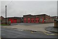
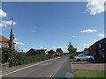
Louth fire station
Louth fire station, Eastfield Road, Louth, Lincolnshire
Image: © Kevin Hale
Taken: 4 Aug 2010
0.23 miles
7
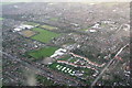
Lacey Gardens and Leisure Centre, Louth: aerial 2015
The wide road bottom left is St. Bernard's Avenue, with its junction with Eastgate (bottom right). The lyre-shaped cul-de-sac of white houses above the caravan storage field is Lacey Gardens, with the Lacey Gardens Primary School and Eastfield Infants' School at the top. Holy Trinity Church just above, on Eastgate.
St.Bernard's Avenue curves around to the right with the Leisure Centre next to it.
Right corner is Monks Dyke School.
Image: © Chris
Taken: 25 Jan 2015
0.24 miles