IMAGES TAKEN NEAR TO
Warren Road, LOUTH, LN11 7RB
Introduction
This page details the photographs taken nearby to Warren Road, LN11 7RB by members of the Geograph project.
The Geograph project started in 2005 with the aim of publishing, organising and preserving representative images for every square kilometre of Great Britain, Ireland and the Isle of Man.

There are currently over 7.5m images from over14,400 individuals and you can help contribute to the project by visiting https://www.geograph.org.uk
Image Map
Images are licensed for reuse under creativecommons.org/licenses/by-sa/2.0
Notes
- Clicking on the map will re-center to the selected point.
- The higher the marker number, the further away the image location is from the centre of the postcode.
Image Listing (17 Images Found)
Images are licensed for reuse under creativecommons.org/licenses/by-sa/2.0
Image
Details
Distance
1
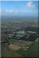
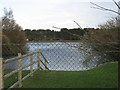
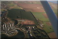
Locksley Hall to North Somercotes Warren: aerial 2022
Image: © Chris
Taken: 6 Mar 2022
0.04 miles
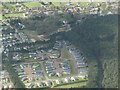
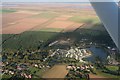
3
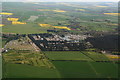
North Somercotes, Lakeside Park: aerial 2014
North Somercotes Church End beyond, with Covenham Reservoir top right in the distance.
For aerial films of this area see: https://www.youtube.com/watch?v=wwhVamd4j6E and https://www.youtube.com/watch?v=zZjqzcMFXi8
These are LiDAR films of the Wolds and Marshes east of Louth. The films are narrated by Jim Broadbent. The land is colour-coded according to its elevation. The films show how the landscape was reclaimed for salt making and grazing. Footage includes ancient river systems, settlements, salterns and ridge and furrow. Produced for the Lincolnshire Coastal Grazing Marshes Project, which has now terminated.
Image: © Chris
Taken: 3 May 2014
0.12 miles
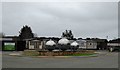
6
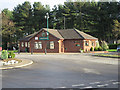
The Reception Block
Of Lakeside Park Caravan Site, North Somercotes.
Image: © Roger Gilbertson
Taken: 5 Dec 2006
0.13 miles
7
North Somercotes Warren and holiday park: aerial 2022 (2)
Image: © Simon Tomson
Taken: 8 Apr 2022
0.14 miles
8
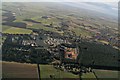
North Smercotess Warren, caravan parks and lakes, to Church End and Grimoldby: aerial 2017
The orange coloured square in the wood was until recently also covered in trees.
Church End centre.
Keeling Street and South Road lead off to the right and converge on Conisholme, with Conisholme Windfarm above.
Covenham Reservoir top right.
Image: © Chris
Taken: 29 Jan 2017
0.19 miles
9
North Somercotes depleted Warren: aerial 2017
Until recently the wood was as in Image, i.e. the development site (centre) was woodland.
Image: © Chris
Taken: 29 Jan 2017
0.19 miles
10
North Somercotes Warren to the sea: aerial 2016
See alaso Image
Image: © Chris
Taken: 8 Oct 2016
0.20 miles