IMAGES TAKEN NEAR TO
Pedlar Lane, LOUTH, LN11 7EX
Introduction
This page details the photographs taken nearby to Pedlar Lane, LN11 7EX by members of the Geograph project.
The Geograph project started in 2005 with the aim of publishing, organising and preserving representative images for every square kilometre of Great Britain, Ireland and the Isle of Man.

There are currently over 7.5m images from over14,400 individuals and you can help contribute to the project by visiting https://www.geograph.org.uk
Image Map (Loading...)


Getting Data...Please wait
Leaflet Map data © OpenStreetMap
Images are licensed for reuse under creativecommons.org/licenses/by-sa/2.0
Notes
- Clicking on the map will re-center to the selected point.
- The higher the marker number, the further away the image location is from the centre of the postcode.
Image Listing (43 Images Found)
Images are licensed for reuse under creativecommons.org/licenses/by-sa/2.0
Image
Details
Distance
1
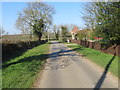
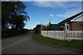
Pedlar Lane in South Cockerington
Looking north-westward.
Image: © Peter Wood
Taken: 27 Feb 2019
0.04 miles
4
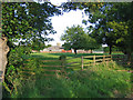
Chapel Lane in South Cockerington
Looking south-westward.
Image: © Peter Wood
Taken: 27 Feb 2019
0.12 miles
5
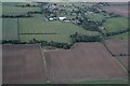
South Cockerington across Grayfleet Drain: aerial 2016
Image: © Chris
Taken: 8 Oct 2016
0.12 miles
6
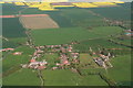
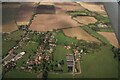
South Cockerington: aerial 2014
Looking eastwards.
Mill Hill Way (part of the Midmarsh Road) runs around the top towards Grimoldby.
Marsh Lane leads eastwards from the left with Northgate Lane parallel to it on the right.
Image: © Chris
Taken: 3 May 2014
0.12 miles
7
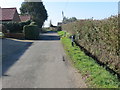
Pedlar Lane from Church Lane, South Cockerington
Image: © Ian S
Taken: 3 Nov 2013
0.14 miles
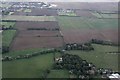
8

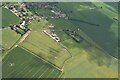
Old field boundaries, South Cockerington: aerial 2015
Image: © Chris
Taken: 25 Mar 2015
0.16 miles
10
Across South Cockerington and Grayfleet Drain to Manby disused airfield: aerial 2016
Ridge and furrow fields to the right and left of Hall Farm.
Image: © Chris
Taken: 8 Oct 2016
0.17 miles