IMAGES TAKEN NEAR TO
School Lane, LOUTH, LN11 7EP
Introduction
This page details the photographs taken nearby to School Lane, LN11 7EP by members of the Geograph project.
The Geograph project started in 2005 with the aim of publishing, organising and preserving representative images for every square kilometre of Great Britain, Ireland and the Isle of Man.

There are currently over 7.5m images from over14,400 individuals and you can help contribute to the project by visiting https://www.geograph.org.uk
Image Map (Loading...)


Getting Data...Please wait
Leaflet Map data © OpenStreetMap
Images are licensed for reuse under creativecommons.org/licenses/by-sa/2.0
Notes
- Clicking on the map will re-center to the selected point.
- The higher the marker number, the further away the image location is from the centre of the postcode.
Image Listing (18 Images Found)
Images are licensed for reuse under creativecommons.org/licenses/by-sa/2.0
Image
Details
Distance
1
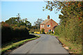
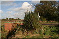
School Lane
Autumnal scene on School Lane, North Cockerington
Image: © Richard Croft
Taken: 25 Oct 2010
0.01 miles
2

Midmarsh Road to Grimsby
Louth Canal runs (between high banks) across the bottom. The Humber Bank industry is visible at the top, and Covenham Reservoir centre-right.
Image: © Chris
Taken: 7 Nov 2010
0.07 miles
3
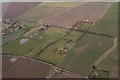
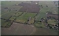
Moated site near North Cockerington: aerial 2018
Image: © Chris
Taken: 13 Mar 2018
0.13 miles
4
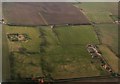
Moated site and enclosure marks south of North Cockerington: aerial 2018
Described as medieval or post medieval settlement, possibly relating to the village of North Cockerington mentioned in the Domesday Book. This is the southern section of the village site. See: http://www.pastscape.org.uk/maps.aspx?a=0&hob_id=1060918&criteria=North%20Cockerington&search=all&rational=q&recordsperpage=10&sort=4&mv=s
The moated site around which it is positioned is the site of North Cockerington Hall, of which there are no visible remains. See: http://www.pastscape.org.uk/hob.aspx?hob_id=354731&sort=4&search=all&criteria=North%20Cockerington&rational=q&recordsperpage=10
Image: © Chris
Taken: 17 Feb 2018
0.14 miles
5
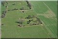
North Cockerington Hall, moated site: aerial 2006
See: https://www.heritagegateway.org.uk/Gateway/Results_Single.aspx?uid=836a927c-5934-4ece-8686-5cfd98bd67fe&resourceID=19191 and https://www.heritagegateway.org.uk/Gateway/Results_Single.aspx?uid=MLI83365&resourceID=1006
Image: © Chris
Taken: 5 Apr 2006
0.14 miles
6
Nice new bridge parapet over the Green Dike
Some years back white painted soft-wood fences were erected on the sides of the bridges in this area.
These have now rotted away, and this one at least has been replaced, though I seem to remember they also strengthened the bridge.
Taken from the footpath to Keddington Corner.
Image: © Chris
Taken: 17 Oct 2012
0.14 miles
7
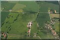
Moated site and farmland south of North Cockerington: aerial 2018
Image: © Chris
Taken: 7 Feb 2018
0.16 miles
8
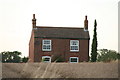
Stylish brickwork, Cockerington
See also: Image
Flemish bond (alternate headers and stretchers), at Well Fitts Farm. This pattern, with light-coloured headers and darker stretchers, is common on farm cottages in this area of Lincolnshire. See also Image
Image: © Chris
Taken: 2 Sep 2012
0.16 miles
9
Part of site of Settlement of North Cockerington: aerial 2021
The settlement of North Cockerington (also known as Cockerington St Mary) is first documented in the Domesday Book, and therefore probably has its origins in the Anglo-Saxon period. See: https://www.heritagegateway.org.uk/Gateway/Results_Single.aspx?uid=MLI83365&resourceID=1006
Included is the moated site of North Cockerington Hall, top left: https://www.heritagegateway.org.uk/Gateway/Results_Single.aspx?uid=836a927c-5934-4ece-8686-5cfd98bd67fe&resourceID=19191
Image: © Chris
Taken: 13 Jun 2021
0.17 miles
10
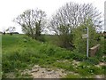
Footpath sign and no horses sign near North Cockerington
Image: © Steve Fareham
Taken: 15 May 2016
0.17 miles