IMAGES TAKEN NEAR TO
Longleat Drive, LOUTH, LN11 0YW
Introduction
This page details the photographs taken nearby to Longleat Drive, LN11 0YW by members of the Geograph project.
The Geograph project started in 2005 with the aim of publishing, organising and preserving representative images for every square kilometre of Great Britain, Ireland and the Isle of Man.

There are currently over 7.5m images from over14,400 individuals and you can help contribute to the project by visiting https://www.geograph.org.uk
Image Map (Loading...)


Getting Data...Please wait
Leaflet Map data © OpenStreetMap
Images are licensed for reuse under creativecommons.org/licenses/by-sa/2.0
Notes
- Clicking on the map will re-center to the selected point.
- The higher the marker number, the further away the image location is from the centre of the postcode.
Image Listing (20 Images Found)
Images are licensed for reuse under creativecommons.org/licenses/by-sa/2.0
Image
Details
Distance
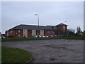
1
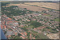
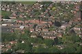
Louth hospital and Louth north, aerial 2007
The hospital is just right of, and above, the centre. The building site bottom right is now a housing estate. Note the Charles St.tennis courts (green with red centres) and fishing pond, just below centre, and allotments at the bottom.
Image: © Chris
Taken: 5 Aug 2007
0.08 miles
2
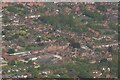
Louth Hospital: aerial 2021 (1)
Formerly Louth Workhouse: see Image
Image: © Chris
Taken: 5 Jun 2021
0.09 miles
3
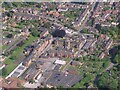
Louth Hospital: aerial 2021 (2)
Formerly Louth Workhouse: see Image
Image: © Simon Tomson
Taken: 5 Jun 2021
0.09 miles
4
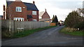
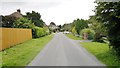
Fanthorpe Lane: the old "Barton Street"?
This unassuming little lane on the edge of Louth seems to follow the line of the old "Barton Street". The main road, the A18, sidesteps to join the A16 at Ludborough, leaving the old road to continue as a minor road, parallel to the A16, as far as Utterby.
Here, this minor road turns left to link with the A16 in Utterby village. The old line of the Barton Street carries on, but now reduced to a bridleway, and then a footpath, which eventually turns into Fanthorpe Lane.
See: Image (old Barton Street at Utterby).
Image: © Chris
Taken: 5 Dec 2012
0.09 miles
5
Louth Hospital: aerial 2021 (3)
Formerly Louth Workhouse: see Image
Image: © Chris
Taken: 5 Jun 2021
0.09 miles
6
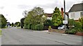
Grimsby Road, Louth
The sign tells us it's a "Designated area of outstanding PROFITABILITY", the meaning not clear to us as we walked by, but probably referring to some development plan in the countryside.
Image: © Chris Morgan
Taken: 18 Aug 2014
0.11 miles
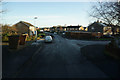
10
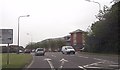
North Holme road at Grimsby road junction
Grimsby Road turns off to the right to the Town centre. This was the old road into Louth before the by pass was constructed
Image: © John Firth
Taken: 11 Jun 2013
0.19 miles