IMAGES TAKEN NEAR TO
King Street, LOUTH, LN11 0PN
Introduction
This page details the photographs taken nearby to King Street, LN11 0PN by members of the Geograph project.
The Geograph project started in 2005 with the aim of publishing, organising and preserving representative images for every square kilometre of Great Britain, Ireland and the Isle of Man.

There are currently over 7.5m images from over14,400 individuals and you can help contribute to the project by visiting https://www.geograph.org.uk
Image Map (Loading...)


Getting Data...Please wait
Leaflet Map data © OpenStreetMap
Images are licensed for reuse under creativecommons.org/licenses/by-sa/2.0
Notes
- Clicking on the map will re-center to the selected point.
- The higher the marker number, the further away the image location is from the centre of the postcode.
Image Listing (202 Images Found)
Images are licensed for reuse under creativecommons.org/licenses/by-sa/2.0
Image
Details
Distance
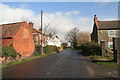
2
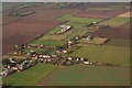
King St., Yarburgh, looking west
Floods, June 2007
Image: © Chris
Taken: 21 Jul 2007
0.02 miles
3
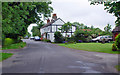
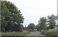
King Street, Yarburgh
Looking slightly south of west, this looks to be a place of peace and quiet.
Image: © Peter Church
Taken: 21 Jun 2008
0.04 miles
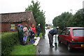
4
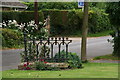
King Street, Yarburgh, chapel railing
There used to be two methodist chapels in King St., and the railing in this garden is all that remains of the eastern one.
A close-up, from the other side, is shown in Image
Image: © Chris
Taken: 21 Aug 2012
0.04 miles
5
King Street, Yarburgh, chapel railing
This is a detail of Peter Church's photo Image
There used to be two methodist chapels in King Street, and this is all that remains of the eastern one.
See also Image
Image: © Chris
Taken: 21 Aug 2012
0.04 miles
6
View northeastwards from Yarburgh church tower, 2002
Image: © Chris
Taken: Unknown
0.05 miles
7
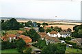
Yarburgh: aerial 2010
Looking up the Midmarsh Road towards Covenham, with King Street running left-right across the bottom (towards Grainthorpe).
The dark lines right of centre are rows of straw bales at Grange Farm.
The road turns sharply left just after the white-roofed sheds, then right again in the top left corner. The windy marsh roads are said to follow the higher ground through the marsh.
However a footpath runs direct to Covenham past the line of houses (and the straw bales) to the first corner in the road and then along the pale brown line (ditch edge).
Image: © Chris
Taken: 7 Nov 2010
0.05 miles
8
King Street in Yarburgh
From near crossroads
Image: © John Firth
Taken: 11 Jun 2013
0.05 miles
9
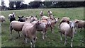
Shorn sheep on the footpath entering Yarburgh from the north (1)
Believed to be Berrichons.
Image: © Chris
Taken: 15 Aug 2020
0.05 miles
10
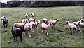
Shorn sheep on the footpath entering Yarburgh from the north (2)
Image: © Chris
Taken: 15 Aug 2020
0.05 miles