IMAGES TAKEN NEAR TO
Ramsgate Road, LOUTH, LN11 0NH
Introduction
This page details the photographs taken nearby to Ramsgate Road, LN11 0NH by members of the Geograph project.
The Geograph project started in 2005 with the aim of publishing, organising and preserving representative images for every square kilometre of Great Britain, Ireland and the Isle of Man.

There are currently over 7.5m images from over14,400 individuals and you can help contribute to the project by visiting https://www.geograph.org.uk
Image Map (Loading...)


Getting Data...Please wait
Leaflet Map data © OpenStreetMap
Images are licensed for reuse under creativecommons.org/licenses/by-sa/2.0
Notes
- Clicking on the map will re-center to the selected point.
- The higher the marker number, the further away the image location is from the centre of the postcode.
Image Listing (139 Images Found)
Images are licensed for reuse under creativecommons.org/licenses/by-sa/2.0
Image
Details
Distance
1
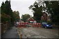
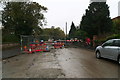
Louth: replacing the sewers in Ramsgate Road
The road runs alongside the River Lud, and is often subject to flooding, which I believe this work should alleviate.
It has been on-going now for 6 months, and another 6 months to go, with the road blocked and a diversion necessary up Newbridge Hill, where the ABM Malt Kiln is being demolished - also requiring road closures.
Meanwhile residents of Ramsgate Road have at times not been able to get their cars into their drives, though they say the workmen have been as helpful as possible.
See also: Image
Image: © Chris
Taken: 18 Oct 2014
0.02 miles
2
Louth: replacing the sewers in Ramsgate Road
The road runs alongside the River Lud, and is often subject to flooding, which I believe this work should alleviate.
It has been on-going now for 6 months, and another 6 months to go, with the road blocked and a diversion necessary up Newbridge Hill, where the ABM Malt Kiln is being demolished - also requiring road closures.
Meanwhile residents of Ramsgate Road have at times not been able to get their cars into their drives, though they say the workmen have been as helpful as possible.
See also: Image
Image: © Chris
Taken: 18 Oct 2014
0.02 miles
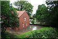
5
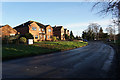
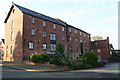
Louth Riverhead, Bryan Hall Mill
This photo shows Bryan Hall's name still visible on the end of the building.
Bryan sold the Bryan Hall Crown Mills complex for development when he retired. The estate is named "Old Mill Park". He died in 2006, bringing to an end a tradition of milling in Louth that goes back nearly 200 years to a time when the Hall family owned windmills (which were destroyed by fire in 1873 and 1905) and later the watermill in Ramsgate Road. The mill derived its power from the river Lud, supplemented by a turn-of-the-century Ruston Bucyrus diesel engine. Animal feeds, mixed from local cereals, and with evocative names such as Growers' Mash and Layers' Mash (for hens), were supplied to the farmers of East Lindsey; the Three Crowns flour with its endorsement "pura et nivea" was also used throughout the district, including by another branch of the family, Alfred Hall, bakers.
Bryan was a man of his time and place. Louth after the second world war relied on its merchants and traders for a sense of civic wellbeing. He was a founder member of the Round Table and president of the local 41 Club. He also helped establish Louth jazz club, which, for a time, met at the mill.
http://www.guardian.co.uk/news/2006/jan/18/obituaries.mainsection
Image: © Chris
Taken: 7 Aug 2012
0.04 miles
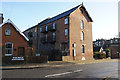
6
Louth Riverhead, Bryan Hall Mill
Bryan Hall sold the Bryan Hall Crown Mills complex for development when he retired. The estate is named "Old Mill Park". In photo Image] his name can still be seen on the end of this building.
He died in 2006, bringing to an end a tradition of milling in Louth that goes back nearly 200 years to a time when the Hall family owned windmills (which were destroyed by fire in 1873 and 1905) and later the watermill in Ramsgate Road. The mill derived its power from the river Lud, supplemented by a turn-of-the-century Ruston Bucyrus diesel engine. Animal feeds, mixed from local cereals, and with evocative names such as Growers' Mash and Layers' Mash (for hens), were supplied to the farmers of East Lindsey; the Three Crowns flour with its endorsement "pura et nivea" was also used throughout the district, including by another branch of the family, Alfred Hall, bakers.
Bryan was a man of his time and place. Louth after the second world war relied on its merchants and traders for a sense of civic wellbeing. He was a founder member of the Round Table and president of the local 41 Club. He also helped establish Louth jazz club, which, for a time, met at the mill.
http://www.guardian.co.uk/news/2006/jan/18/obituaries.mainsection
Image: © Chris
Taken: 7 Aug 2012
0.05 miles
8
No trains here anymore
The Old Railway Station the last passenger train departed way back in 1970. Open for freight for another ten years before the railway was closed for ever. Now the station buildings have been converted into flats and the railway yard and land have new dwellings on them making it very hard to imagine that trains ever ran here.
Image: © roger geach
Taken: 14 Oct 2011
0.05 miles
9
Louth Flood, June 2007
The River Lud floods properties between Ramsgate Road and Eastgate.
View from the old railway bridge.
Image: © Chris
Taken: 25 Jun 2007
0.06 miles
10
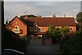
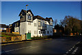
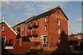
Louth Riverhead, Old Mill Park
Bryan Hall sold the Bryan Hall Crown Mills complex for development when he retired. The estate is named "Old Mill Park". This is one of the buildings on the estate.
http://www.guardian.co.uk/news/2006/jan/18/obituaries.mainsection
Image]; Image]; Image]; Image]
Image: © Chris
Taken: 7 Aug 2012
0.07 miles