IMAGES TAKEN NEAR TO
Broadbank, LOUTH, LN11 0EW
Introduction
This page details the photographs taken nearby to Broadbank, LN11 0EW by members of the Geograph project.
The Geograph project started in 2005 with the aim of publishing, organising and preserving representative images for every square kilometre of Great Britain, Ireland and the Isle of Man.

There are currently over 7.5m images from over14,400 individuals and you can help contribute to the project by visiting https://www.geograph.org.uk
Image Map (Loading...)


Getting Data...Please wait
Leaflet Map data © OpenStreetMap
Images are licensed for reuse under creativecommons.org/licenses/by-sa/2.0
Notes
- Clicking on the map will re-center to the selected point.
- The higher the marker number, the further away the image location is from the centre of the postcode.
Image Listing (281 Images Found)
Images are licensed for reuse under creativecommons.org/licenses/by-sa/2.0
Image
Details
Distance
1
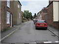
Union Street
A narrow road leading to the hospital.
Image: © Paddy Griffin
Taken: 18 Jul 2010
0.04 miles
3

Cisterngate
An interesting road close to the hospital. The view looks west towards the old A16. The houses in the area are a mixture of edwardian terraces and inner war social housing.
Image: © Paddy Griffin
Taken: 18 Jul 2010
0.05 miles
4
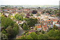
A prospect of Louth
View north from St.James' church tower, begun in 1501 and completed in 1515, at 295ft, it is the tallest medieval church spire in England.
Image: © Richard Croft
Taken: 2 May 2011
0.06 miles
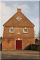
6
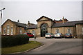
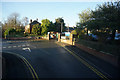
Louth Workhouse
It now serves as the entrance to Louth County Hospital, but this austere portico was the entrance to Louth Workhouse, built in 1837 to the design of George Gilbert Scott at a cost of £8,000. The three storey building behind housed most of the 300 paupers but is now part of the hospital.
Image: © Richard Croft
Taken: 7 Mar 2006
0.08 miles
7
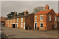
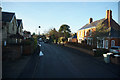
Broadbank
Early 19th century cottages on Broadbank
Image: © Richard Croft
Taken: 13 Mar 2015
0.09 miles
8
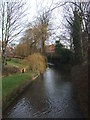
River Lud at Louth
Peaceful now but subject to a serious flood 29 May 1920, causing 23 deaths in 20 minutes. https://www.louthtowncouncil.gov.uk/great-flood-of-louth-1920/ Image] Image]
Image: © Richard Hoare
Taken: 16 Feb 2012
0.11 miles
9
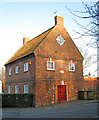
The Mill
Situated on the River Ludd on Bridge Street. This Grade II Listed mill house was built in 1742 and has a plaque inscribed 'Fran Julian Engineer 1755' above the door. It was converted by the Civic Trust in 1975 for the people of Louth and is now a private home.
Image: © Trevor Rickard
Taken: 12 Mar 2014
0.11 miles
10
The Old Mill
Grade II listed former watermill on the River Lud on Bridge Street, built in 1755, it was converted to a dwelling 1973-76
Image: © Richard Croft
Taken: 13 Mar 2015
0.11 miles