IMAGES TAKEN NEAR TO
Grosvenor Road, LOUTH, LN11 0BB
Introduction
This page details the photographs taken nearby to Grosvenor Road, LN11 0BB by members of the Geograph project.
The Geograph project started in 2005 with the aim of publishing, organising and preserving representative images for every square kilometre of Great Britain, Ireland and the Isle of Man.

There are currently over 7.5m images from over14,400 individuals and you can help contribute to the project by visiting https://www.geograph.org.uk
Image Map (Loading...)


Getting Data...Please wait
Leaflet Map data © OpenStreetMap
Images are licensed for reuse under creativecommons.org/licenses/by-sa/2.0
Notes
- Clicking on the map will re-center to the selected point.
- The higher the marker number, the further away the image location is from the centre of the postcode.
Image Listing (69 Images Found)
Images are licensed for reuse under creativecommons.org/licenses/by-sa/2.0
Image
Details
Distance

3

Old Direction Sign - Signpost by Brackenborough Road, Louth Parish
Ball finial - 2 arms; by the UC road, in parish of Louth (East Lindsey District), junction of Brackenborough Road with Keddington Road, against brick garden wall and hedge.
Surveyed
Milestone Society National ID: LI_TF3388.
Image: © Milestone Society
Taken: Unknown
0.14 miles
4
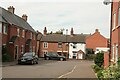
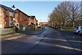
Looking northwards from the Louth Canal to what used to be Eel Mire Lane
The old terrace is lower-lying than the modern housing estate.
Image: © Chris
Taken: 13 Sep 2020
0.14 miles
5
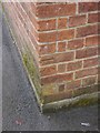
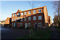
Cut Mark: Louth Riverhead Theatre
Cut mark on the west angle of the theatre, formerly Victoria Hall. See http://www.geograph.org.uk/photo/5721344 for a wider view and http://www.bench-marks.org.uk/bm94051 for details of the mark.
Image: © Brian Westlake
Taken: 15 Mar 2018
0.16 miles
6
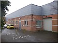
Louth Riverhead Theatre
There is a cut bench mark on the west angle of the theatre, formerly Victoria Hall. See http://www.geograph.org.uk/photo/5721339 for a closer view and http://www.bench-marks.org.uk/bm94051 for details of the mark.
Image: © Brian Westlake
Taken: 15 Mar 2018
0.16 miles
7
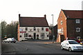
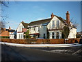
Woolpack, Louth Riverhead
One of the Riverhead's two public houses from the days of canal traffic. It was built shortly after the canal opened in 1770.
It had its own brewery, and stables for the farm horses which brought corn and wool to the Riverhead and took away cottonseed, linseed and groceries.
It is still a thriving pub of great character.
Close behind the Woolpack was the other pub, The Ship, which has now been demolished.
Image: © Chris
Taken: 21 Apr 2011
0.16 miles