IMAGES TAKEN NEAR TO
Bridge Street, LLANGEFNI, LL77 7PP
Introduction
This page details the photographs taken nearby to Bridge Street, LL77 7PP by members of the Geograph project.
The Geograph project started in 2005 with the aim of publishing, organising and preserving representative images for every square kilometre of Great Britain, Ireland and the Isle of Man.

There are currently over 7.5m images from over14,400 individuals and you can help contribute to the project by visiting https://www.geograph.org.uk
Image Map (Loading...)


Getting Data...Please wait
Leaflet Map data © OpenStreetMap
Images are licensed for reuse under creativecommons.org/licenses/by-sa/2.0
Notes
- Clicking on the map will re-center to the selected point.
- The higher the marker number, the further away the image location is from the centre of the postcode.
Image Listing (77 Images Found)
Images are licensed for reuse under creativecommons.org/licenses/by-sa/2.0
Image
Details
Distance
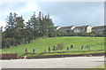
1
Cylch yr Orsedd Llangefni Gorsedd Circle
The National Eisteddfod was held at Llangefni in 1957 and 1983. The 1999 Llangefni Eisteddfod was held nearby at Llanbedrgoch.
Image: © Alan Fryer
Taken: 20 Apr 2007
0.05 miles
4
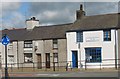
The Constituency Offices of Daf and Dave
The Westminster seat is currently held by Dai - the Welsh Labour Party, and the Welsh Assembly seat by Daf, but, as the blue sign reminds one, Anglesey is a fickle constituency. Since WWII it has in turn returned Liberal, Labour, Conservative and Plaid Cymru members to Westminster.
Image: © Eric Jones
Taken: 13 Sep 2008
0.07 miles
5
Ysbyty Cefni Hospital
This recently built community hospital stands behind the Somerfield supermarket. It replaced two out-dated unit, the Druid and Cefni Hospitals.
Image: © Eric Jones
Taken: 21 Jul 2008
0.07 miles
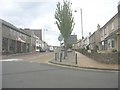
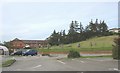
6

The road from Menai Bridge
Looking towards Llangefni town centre.
Image: © David Medcalf
Taken: 15 Oct 2009
0.09 miles
7
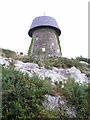
Melin Wynt Y Graig
Thought to have been built in 1829, it closed in 1893. Now used for telecommunications.
Image: © Chris Andrews
Taken: 20 Sep 2014
0.10 miles
8
Old windmill, new use
Standing on a low crag in Llangefni, this former windmill is now used for telecommunications.
Image: © Gordon Hatton
Taken: 25 Sep 2023
0.10 miles
9

Old Milestone by Llangefni library
By the UC (was B5109), in parish of Llangefni (Anglesey District), outside library.
Surveyed
Milestone Society National ID: ANG_OHH17
Image: © Milestone Society
Taken: Unknown
0.11 miles
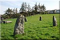
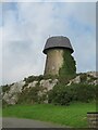
10
The Gorsedd Stones and Disused Windmill at Pencraig
The stone circle is considerably younger than the mill. Consisting of a ring of upright stones surrounding an altar slab (Y Maen Llog), it is where the Eisteddfodic Druids conduct their slightly comical masonic-based rituals. At least these stones are real. In recent times rising costs have led to the introduction of tacky looking plastic stones. The link shows a photo of the circle taken by Francis Frith Ltd c.1960 long before the houses were built.
http://www.francisfrith.com/search/wales/gwynedd/llangefni/photos/llangefni_L364060.htm
Image: © Eric Jones
Taken: 13 Sep 2008
0.12 miles