IMAGES TAKEN NEAR TO
Red Wharf Bay, PENTRAETH, LL75 8HJ
Introduction
This page details the photographs taken nearby to LL75 8HJ by members of the Geograph project.
The Geograph project started in 2005 with the aim of publishing, organising and preserving representative images for every square kilometre of Great Britain, Ireland and the Isle of Man.

There are currently over 7.5m images from over14,400 individuals and you can help contribute to the project by visiting https://www.geograph.org.uk
Image Map (Loading...)


Getting Data...Please wait
Leaflet Map data © OpenStreetMap
Images are licensed for reuse under creativecommons.org/licenses/by-sa/2.0
Notes
- Clicking on the map will re-center to the selected point.
- The higher the marker number, the further away the image location is from the centre of the postcode.
Image Listing (11 Images Found)
Images are licensed for reuse under creativecommons.org/licenses/by-sa/2.0
Image
Details
Distance
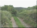
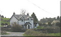
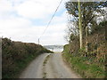
2
View back to the lower slopes of Mynydd Llwydiarth
Image: © Eric Jones
Taken: 5 Apr 2007
0.15 miles
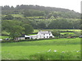
4
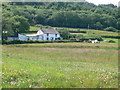
Tyddyn y Waen
Smallholding seen from the Anglesey Coast Path.
Image: © Eirian Evans
Taken: 5 Jul 2013
0.19 miles
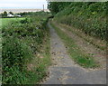
5
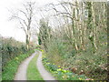
Daffodil-fringed driveway on the northern slopes of Mynydd Llwydiarth
This private driveway is a right of way for walkers.
Image: © Eric Jones
Taken: 5 Apr 2007
0.19 miles
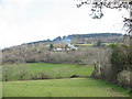
6
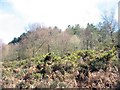
Birch trees and whins on the slope below the Pentraeth Forest
Image: © Eric Jones
Taken: 5 Apr 2007
0.19 miles
8
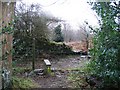
Forest Boundary
The edge of the Pentraeth Forest where the footpath begins its descent towards the Anglesey Coastal Path and the car park to the south of Red Wharf Bay.
Image: © John S Turner
Taken: 26 Jan 2007
0.23 miles