IMAGES TAKEN NEAR TO
Llanfairynghornwy, HOLYHEAD, LL65 4LR
Introduction
This page details the photographs taken nearby to LL65 4LR by members of the Geograph project.
The Geograph project started in 2005 with the aim of publishing, organising and preserving representative images for every square kilometre of Great Britain, Ireland and the Isle of Man.

There are currently over 7.5m images from over14,400 individuals and you can help contribute to the project by visiting https://www.geograph.org.uk
Image Map
Images are licensed for reuse under creativecommons.org/licenses/by-sa/2.0
Notes
- Clicking on the map will re-center to the selected point.
- The higher the marker number, the further away the image location is from the centre of the postcode.
Image Listing (12 Images Found)
Images are licensed for reuse under creativecommons.org/licenses/by-sa/2.0
Image
Details
Distance
1
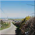
Approaching Mynachdy Farm along the private farm road
Image: © Eric Jones
Taken: 2 Apr 2009
0.01 miles
2
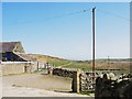
The old Mynachdy drive leading to the Cemlyn-Tregele road
This old driveway is now used as a farm track. The ruins of a former lodge stands near its eastern end. The track may be used by walkers.
Image: © Eric Jones
Taken: 2 Apr 2009
0.02 miles
3
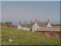
Mynachdy - the northernmost manor house in Wales
Image: © Eric Jones
Taken: 2 Apr 2009
0.05 miles
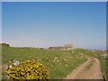
7
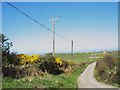
The Mynachdy farm road
Public rights of way for walkers only exist along this road and it affords access to the farm track to Carmel Head.
Image: © Eric Jones
Taken: 2 Apr 2009
0.15 miles
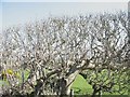
8
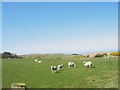
Grazing sheep on land between Bryn Goelcerth and Mynachdy
Image: © Eric Jones
Taken: 2 Apr 2009
0.16 miles
9
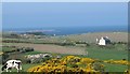
Bryn Goelcerth from the Mynydd y Garn road
The "White Ladies" navigation beacons at Carmel Head, and the Skerries beyond, can be seen on the left. The farmlands around the house, now parts of Mynachdy farm, are the most north-westerly in Wales.
Image: © Eric Jones
Taken: 25 Apr 2009
0.21 miles
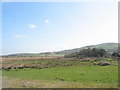
10
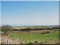
View across pasture land towards the wetland flat east of Mynachdy
The pasture land occupies drier sections above the valley floor wetlands. A pond and a shelter belt form features of the wetland.
Image: © Eric Jones
Taken: 2 Apr 2009
0.24 miles