IMAGES TAKEN NEAR TO
Trearddur Bay, HOLYHEAD, LL65 2TU
Introduction
This page details the photographs taken nearby to LL65 2TU by members of the Geograph project.
The Geograph project started in 2005 with the aim of publishing, organising and preserving representative images for every square kilometre of Great Britain, Ireland and the Isle of Man.

There are currently over 7.5m images from over14,400 individuals and you can help contribute to the project by visiting https://www.geograph.org.uk
Image Map
Images are licensed for reuse under creativecommons.org/licenses/by-sa/2.0
Notes
- Clicking on the map will re-center to the selected point.
- The higher the marker number, the further away the image location is from the centre of the postcode.
Image Listing (12 Images Found)
Images are licensed for reuse under creativecommons.org/licenses/by-sa/2.0
Image
Details
Distance
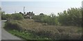
1
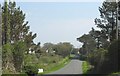
Approaching the eastern end of Lon Towyn Capel
The public highway turns sharply north towards the town of Holyhead at the bend in the background. The lane marking the continuation of Lon Towyn Capel is a private road which extends to the Anglesey Aluminium Works.
Image: © Eric Jones
Taken: 7 May 2008
0.03 miles
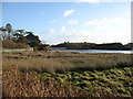
2
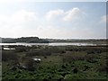
Saltmarsh at Trearddur
A view looking to the southwest over saltmarsh and an inlet of the Inland Sea towards Trearddur.
Image: © Phil Williams
Taken: 21 Apr 2006
0.06 miles
3
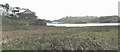
A creek of the Inland Sea
The Inland Sea separates Holy Island (Ynys Gybi) from the Island of Anglesey (Ynys Môn).
Image: © Eric Jones
Taken: 7 May 2008
0.08 miles
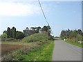
5
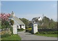
View east along Towyn y Capel Road towards Creigle house
Image: © Eric Jones
Taken: 7 May 2008
0.11 miles
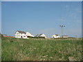
6
View west along Lon Towyn Capel near Creigle
Image: © Eric Jones
Taken: 7 May 2008
0.11 miles
7
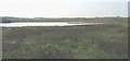
An inlet from Holyhead Bay
Some descriptions call this 'Inland Sea', though I have not found this on any map.
Image: © David Purchase
Taken: 26 Dec 2016
0.15 miles
10
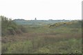
View southwards across the saltings
Stanley Mill can be seen in the distance. This is an old windmill converted into a house.
Image: © Eric Jones
Taken: 7 May 2008
0.20 miles