IMAGES TAKEN NEAR TO
Bryn Glas Close, HOLYHEAD, LL65 2ER
Introduction
This page details the photographs taken nearby to Bryn Glas Close, LL65 2ER by members of the Geograph project.
The Geograph project started in 2005 with the aim of publishing, organising and preserving representative images for every square kilometre of Great Britain, Ireland and the Isle of Man.

There are currently over 7.5m images from over14,400 individuals and you can help contribute to the project by visiting https://www.geograph.org.uk
Image Map
Images are licensed for reuse under creativecommons.org/licenses/by-sa/2.0
Notes
- Clicking on the map will re-center to the selected point.
- The higher the marker number, the further away the image location is from the centre of the postcode.
Image Listing (10 Images Found)
Images are licensed for reuse under creativecommons.org/licenses/by-sa/2.0
Image
Details
Distance
1
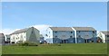
Attractively painted maisonettes on the Mor Awelon Estate
Image: © Eric Jones
Taken: 4 Jul 2008
0.05 miles
2
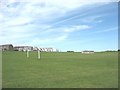
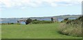
Recreation ground on cliff-top fields below Maes Awelon Estate
Image: © Eric Jones
Taken: 4 Jul 2008
0.14 miles
3
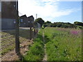
Anglesey Coast Path
The path goes north west beside the former factory of Eaton Electric
Image: © Eirian Evans
Taken: 18 Jun 2015
0.15 miles
4
Ysbyty Penrhos Stanley, Holyhead
This modern hospital, which specializes in the care of the elderly, was built 1996 to replace the Stanley Sailor's Hospital on Salt Island and the Valley Hospital (the former Valley Workhouse).
www.northwestwales.org/WiSSCMS-en-306.aspx
Image: © Eric Jones
Taken: 4 Jul 2008
0.18 miles
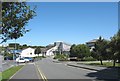
5
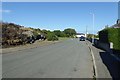
Along Llanfawr Road
Looking along Llanfawr Road in Holyhead.
Image: © DS Pugh
Taken: 5 Aug 2018
0.20 miles
6
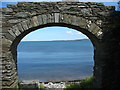
Arch leading to Pwll y Gwman
Gwman is a corruption of "gwymon" (=seaweed).
Image: © Eric Jones
Taken: 4 Jul 2008
0.21 miles
7
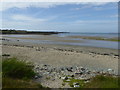
The coastline east of Holyhead
A wide sandy bay, but around the next headland is the ferry port for vessels going to Ireland
Image: © Eirian Evans
Taken: 18 Jun 2015
0.22 miles
8
Fortifications at Peibio Point
These were built to deter Napoleon from invading Holyhead.
Image: © Eric Jones
Taken: 4 Jul 2008
0.23 miles
9
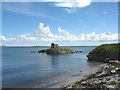
Inlet west of Ynys Peibio
The defence structure on the island - Ynys Peibio - was built to repulse any attack on the port by the French Napoleonic navy.
Image: © Eric Jones
Taken: 4 Jul 2008
0.25 miles
10
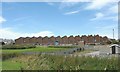
The MEM Factory at Maes Awelon
This is a government established factory dating back to the 1960s. It produces a range of electrical goods
www.holyhead.com/mem/index.html
Image: © Eric Jones
Taken: 4 Jul 2008
0.25 miles