IMAGES TAKEN NEAR TO
Peibio Close, HOLYHEAD, LL65 2EG
Introduction
This page details the photographs taken nearby to Peibio Close, LL65 2EG by members of the Geograph project.
The Geograph project started in 2005 with the aim of publishing, organising and preserving representative images for every square kilometre of Great Britain, Ireland and the Isle of Man.

There are currently over 7.5m images from over14,400 individuals and you can help contribute to the project by visiting https://www.geograph.org.uk
Image Map
Images are licensed for reuse under creativecommons.org/licenses/by-sa/2.0
Notes
- Clicking on the map will re-center to the selected point.
- The higher the marker number, the further away the image location is from the centre of the postcode.
Image Listing (20 Images Found)
Images are licensed for reuse under creativecommons.org/licenses/by-sa/2.0
Image
Details
Distance
1
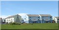
Attractively painted maisonettes on the Mor Awelon Estate
Image: © Eric Jones
Taken: 4 Jul 2008
0.03 miles
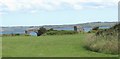
2
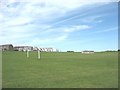
Recreation ground on cliff-top fields below Maes Awelon Estate
Image: © Eric Jones
Taken: 4 Jul 2008
0.11 miles
3
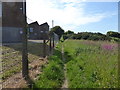
Anglesey Coast Path
The path goes north west beside the former factory of Eaton Electric
Image: © Eirian Evans
Taken: 18 Jun 2015
0.13 miles
4
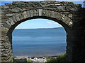
Arch leading to Pwll y Gwman
Gwman is a corruption of "gwymon" (=seaweed).
Image: © Eric Jones
Taken: 4 Jul 2008
0.17 miles
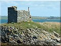
5
Fortifications at Peibio Point
These were built to deter Napoleon from invading Holyhead.
Image: © Eric Jones
Taken: 4 Jul 2008
0.18 miles
6
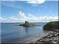
Inlet west of Ynys Peibio
The defence structure on the island - Ynys Peibio - was built to repulse any attack on the port by the French Napoleonic navy.
Image: © Eric Jones
Taken: 4 Jul 2008
0.18 miles
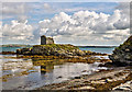
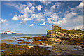
7
Peibio castle
Peibio castle situated on Ynys Peibio. The Castle was built because of the threat of the French invasion in 1802, and is a small tower-like structure
Image: © Nigel Williams
Taken: 17 Aug 2004
0.22 miles
8
North Wales WWII defences: Holyhead, Anglesey - Ynys Peibio pillbox (1)
-
Pillbox (variant): DoB ID: S0011350
Cut off at high tide on a tiny island, this rectangular structure at Ynys Peibio protected the eastern approaches to the harbour at Holyhead and Penrhos Beach.
Image
Image: © Mike Searle
Taken: 19 Sep 2017
0.22 miles
9
North Wales WWII defences: Holyhead, Anglesey - Ynys Peibio pillbox (2)
-
Pillbox (variant): DoB ID: S0011350
Image
Image: © Mike Searle
Taken: 19 Sep 2017
0.22 miles
10
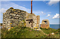
North Wales WWII defences: Holyhead, Anglesey - Ynys Peibio pillbox (3)
-
Pillbox (variant): DoB ID: S0011350
The pillbox is in a fragmentary condition making it difficult to interpret, but it would appear that it originally was a non-defensive structure that was subsequently modified during WW2 with concrete reinforcement containing embrasures with loopholes.
Image
Image: © Mike Searle
Taken: 19 Sep 2017
0.22 miles